The working relationship between members of the International Air Transport Association and the World Meteorological Organization has been particularly useful for nowcasting situations, where conditions are changing rapidly and are therefore of special use to the aviation industry.
A noteworthy example illustrating the immediate usefulness of Aircraft Meteorological Data Relay (AMDAR) information occurred on Feb. 6, 1998. An airliner flying from Italy to the U.S. had experienced sustained, stronger-than-anticipated headwinds over the Atlantic. The flight crew’s fuel tracking predicted the possibility of fuel exhaustion prior to reaching the destination.
The fuel status was approaching a critical condition. The flight crew urgently needed to find an altitude that would offer substantially weaker headwinds. Fortunately, the National Weather Service Miami Central Weather Service Unit noted a flight track over the Bahamas with headwinds that were 40 kts less. Controllers immediately authorized the change in altitude and the aircraft completed the flight without incident.
Reducing Turbulence Encounters
Another realm in which airborne data collection has provided a significant improvement is the measurement of turbulence. Unseen to the naked eye and currently undetectable with standard on-board avionics, clear air turbulence (CAT) often strikes without warning and can toss unbuckled passengers, cabin crew and objects around the cabin, sometimes violently enough to cause fatal injuries.
In the U.S. alone, it costs more than $200 million in compensation for injuries, with people being hospitalized with broken bones and head injuries. The additional costs to airlines that result from cabin and aircraft damage, time lost to inspection and maintenance, and impacts of delays are substantial. In-flight injury of passengers and/or crew may require diversion, a costly option anytime and operationally difficult when over oceanic airspace.
Turbulence has caused more serious injuries to passengers than any other class of accident, according to NTSB Senior Meteorologist Donald Eick. Seventy-one percent of Part 121 air carrier weather related accidents between 2000-11 were due in part to turbulence, with 24% of weather-related accidents tied directly to CAT. The average year (based on Part 121 air carrier data from 1998-2013) has 27 “significant turbulence” incidents and/or accidents resulting in 14 serious injuries and 69 minor injuries.
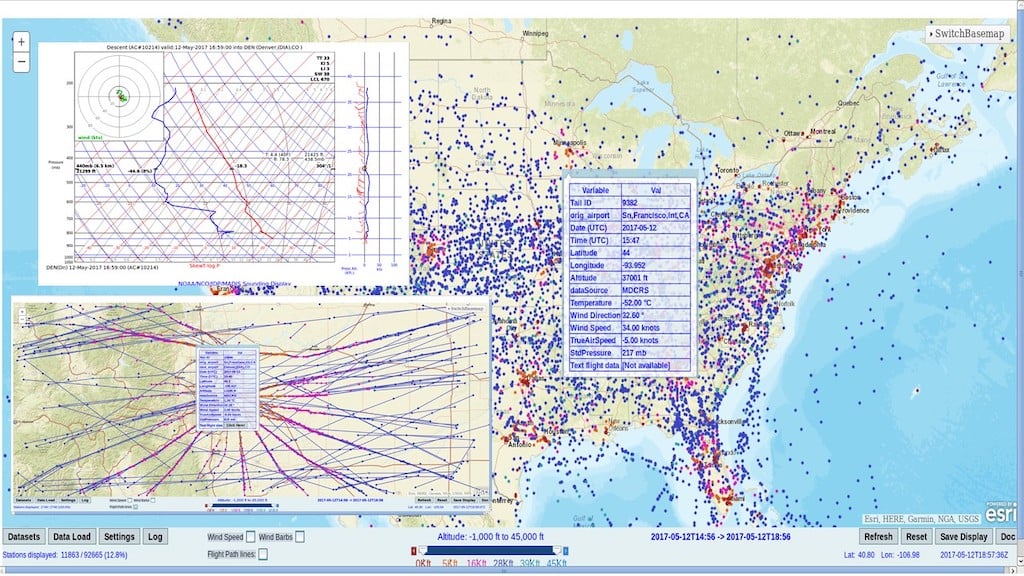
A government-industry collaboration has worked to provide better in-flight turbulence measurements and reporting. The participants included United Air Lines, Delta Air Lines, the Boulder, Colorado-based National Center for Atmospheric Research (NCAR) and the FAA’s Aviation Weather Division. Two hundred commercial aircraft were equipped with modified software that estimated the vertical wind velocity or aircraft vertical acceleration. Since each aircraft’s response to atmospheric turbulence will vary depending on its design characteristics such as wing loading and wing sweep angle, the software developed by NCAR estimated a parameter of the atmosphere termed “Eddy Dissipation Rate” that is independent of aircraft type.
The average and peak values encountered over each minute of flight were automatically downlinked. These values were accurate to within at least 10 km and 1 min., much better than those of typical PIREPs, making them ideal for the evaluation of turbulence in the upper troposphere and lower stratosphere, according to the NCAR.
Software for this program was implemented on the entire fleets of United Boeing 737-300 and 757-200 aircraft, and Delta 737-700/800s. The number of combined reports was unprecedented. It included 128.3 million United 757 reports from 2004-2013 above FL200 and 9.6 million Delta 737 reports from October 2008 to 2013. This provided unprecedented sampling of the turbulent state of the atmosphere, especially at the cruise altitudes at which commercial aircraft spend most of their time.
The data enabled the multi-disciplinary team members to make a number of interesting findings about the upper atmosphere. The median patch length for CAT was found to be 57 km (30.8 nm) in the data collected by the United 757s, and 66 km (35.6 nm) in the data collected by the Delta 737s. This corresponds to flight times of 4.3 min. and 5.6 min, respectively, assuming a cruise speed of approximately 500 kts.
The median depth of the turbulence was 4,600 ft. at lower altitudes; it was 3,000 ft. thick at higher altitudes. The research team stressed that these findings might be somewhat low since they are based on commercial aircraft flights that were trying to avoid known areas of turbulence. An obvious seasonal dependence is exhibited, with seasonal peaks in the spring at all flight levels and in winter at upper levels. This corresponds well with our generalizations about jet stream behavior becoming stronger and moving to more southerly latitudes in the winter. The data sampling also found a peak in the high-altitude turbulence at approximately 36,000 ft.
Based on the success of collaborative projects such as this, major airlines are now using the near-real time data to provide better situational awareness of turbulence within the national airspace system that can be used for tactical avoidance. Further, given the higher reporting frequency and the higher time and position accuracy relative to PIREPs, the data provides a valuable verification and tuning source for turbulence nowcasting/forecasting algorithms that have traditionally been limited to PIREPs.
Vast Improvements In Atmospheric Science
The automated systems employed on commercial aircraft are a vast improvement from the earliest attempts by pilots in open-cockpit biplanes exposing themselves to extreme temperatures and hypoxia. Modern sensors and communications systems on advanced aircraft have become an ideal platform to measure important aspects of the atmosphere. As the volume of data increases, including more measurements of water vapor and turbulence, and regional coverage below FL250 increases, it will become an increasingly important input into atmospheric science.
An important aspect of these global observation sources of data is their free distribution throughout the scientific community. The timely delivery of observations is used in near-term weather forecasting, as well as to support ongoing research activities across disciplines. Open data amplify the broader impact of science and forecast services on the safety and economic viability of a wide spectrum of industries and communities.
As collaborative teams led by atmospheric scientists continue to search for these inter-related factors in our environment, the sophisticated computer models used to predict the weather will be updated, thus rendering more accurate near-term weather predictions. In doing so, our aircraft are improving weather forecasts, as well as directly benefiting from near-term improvements to avoid severe weather.
In-Flight Weather Data Collection, Part 1: https://aviationweek.com/business-aviation/safety-ops-regulation/flight…

Related Content