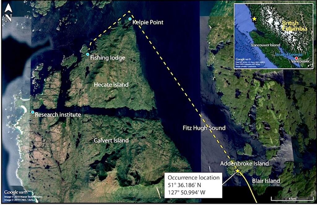
The intended flight path and accident site of the Cessna 208 Caravan.
A float-equipped Cessna 208 Caravan aircraft departed Vancouver International Water Aerodrome (CAM9), British Columbia, on the morning of July 26, 2019, headed for a floating fishing lodge off the northern end of Hecate Island, BC. Ole’s Fishing Lodge was a popular destination for the flight’s operator, Seair Seaplanes, and the company had four flights scheduled to Ole’s or a nearby research institute that morning. Three flights carried passengers and a fourth carried cargo.
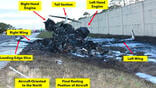
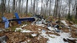
The single-engine Caravan turboprop, registration C-GURL, never made it to the fishing lodge. It struck trees on a remote island while flying at a very low altitude. Of the nine persons aboard, the pilot and three passengers were killed, four passengers were seriously injured, and one passenger received minor injuries. The airplane was destroyed.
When the Transportation Safety Board of Canada (TSB) completed its investigation, its four causal findings sounded very similar to those of the NTSB in similar controlled flight into terrain (CFIT) accidents. There have been many of these accidents further north in southeast Alaska. The TSB’s findings also closely aligned with the FAA’s PAVE flight risk management acronym: P for pilot; A for airplane; V for environment; and E for external pressure. All were present in this accident.
The accident pilot arrived at the base at 0630. He inspected the airplane, added fuel, checked weather and planned the flight. There was poor weather in the central coast region, and all four Caravans that were scheduled to depart were delayed. The accident pilot was supposed to be the first to depart, at 0730, but the order of departures changed as the pilots conferred. One pilot, who was newly upgraded and had never been to the fishing lodge, decided not to fly, and the Seair operations manager stepped in and took the first flight out. He departed at 0850. A second airplane departed at 0906, and the accident airplane departed at 0932. A fourth Caravan, flown by the company’s chief pilot, left at 1024.
After cruising for 51 min. at 4,500 ft. ASL (above sea level), the pilot of C-GURL began a slow descent, arriving at 1300 ft AGL, where he leveled off for 6 min. before continuing his descent. At a point 37 nm south southeast of the lodge he extended the flaps to 10 deg. He continued to descend until he leveled off at 330 ft. ASL.
Other Pilot Reports Heavy Rain
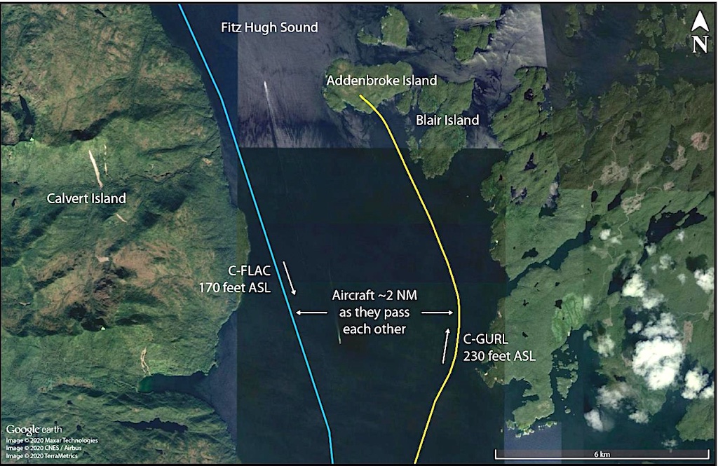
Entering Fitz Hugh Sound from the south, the pilot steered to the right to fly near the eastern shore of the sound and further descended to 230 ft. ASL. The pilot of the lead Seair airplane had already landed at and departed from his destination and was southbound along the western shoreline of the sound when he made radio contact with the accident pilot. The southbound pilot reported heavy rain and visibility of about 1 statute mile. He said he had decided go as low as 170 ft. ASL before climbing back to 330 ft. ASL. He informed the northbound pilot that he had been able to see Addenbroke Island as he passed it.
Shortly after the two pilots conferred, C-GURL began a left turn and entered a shallow climb. It was as though he sensed the island was near but could not see it. At 1104:55, the airplane struck trees on Addenbroke Island in a relatively straight and level attitude at about 490 ft. ASL. It passed through the forested hillside for about 450 ft. before coming to a stop. Its resting place was only 9.7 nm from the destination lodge.
The pilot and the three fatally injured passengers suffered from velocity forces and blunt force trauma. The five surviving passengers were seated in an area where trees and debris did not intrude during the crash sequence. They were able to evacuate through gaps in the fuselage.
The Canadian Mission Control Center received the airplane’s emergency locator transmitter (ELT) signal at 1109 and launched rescue aircraft. A Canadian Coast Guard helicopter located the accident site at 1223 and first responders arrived at the scene at 1252. All survivors were brought aboard the helicopter by 1810 and were transported to hospitals.
Perhaps ironically, the Addenbroke Island Lighthouse station was located only about one-half nm west of the accident site.
The findings of the accident investigation follow in Part 2 of this article.

Related Content