In February 2022, the General Aviation Joint Steering Committee (GAJSC) released a study on collision risk for aircraft in the U.S. Using “big data” from Aviation Safety Information Analysis and Sharing (ASIAS), they plotted simulated traffic conflicts over a three-year period at 50 of the busiest airport areas in the country. The report displays those conflicts graphically.
The GAJSC is a public-private partnership sponsored by the FAA and intended to improve GA safety. “Big data” is information collected in high volume, at high velocity, with much variety. The ASIAS databases are certainly that. They record parameters from just about every flight in the U.S. This is in keeping with the FAA’s long-standing promise to be “data driven.”
The GAJSC study used four sources of data: radar surveillance recordings (also known as the National Offload Program), ADS-B recordings, Flight Operations Quality Assurance (FOQA) data from air carriers, and text-based safety reports. All the data was run through a program that simulated Resolution Advisories (RAs) that an airborne TCAS system would produce.
All the close encounters were counted, plotted and broken into climbing, descending, level, parallel and helicopter categories.
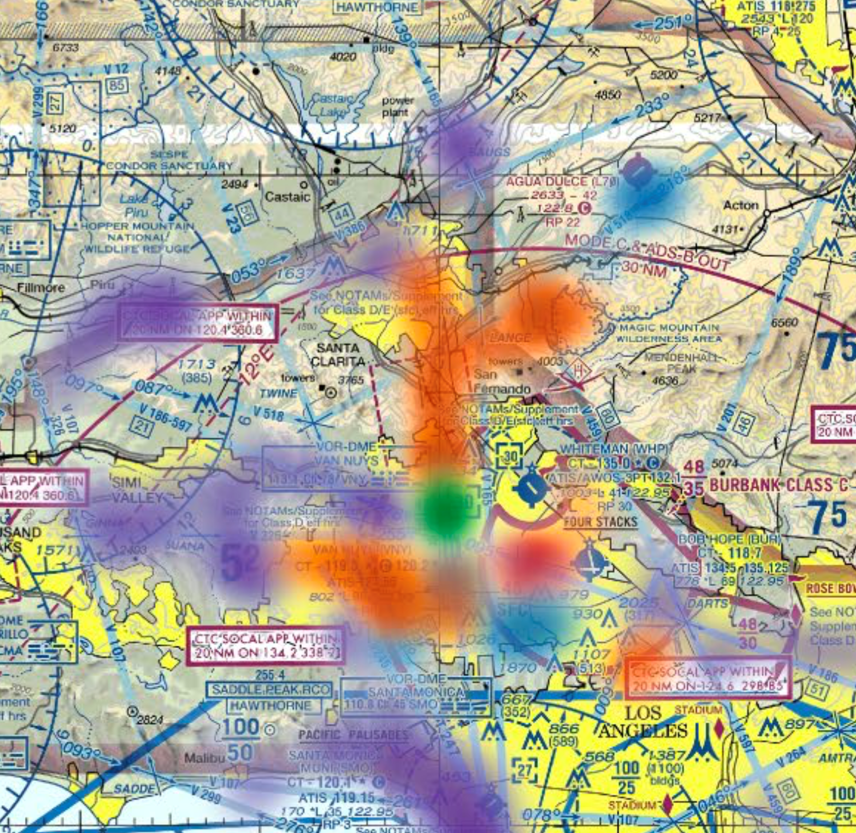
The resulting color-coded arrays, overlaid on sectional charts, provide a dazzling mosaic of thousands of flights operating extremely close together. The bottom of each chart shows the actual count of flights whose horizontal separation was less than 1,000 ft., broken out by hundreds.
For example, on the New York South Central chart, you can see that flights passed within 100 ft. of one another five times in the three-year period of the study.
If you are flying in and out of these busy areas, these graphics merit a closer look. Many corporate and business aircraft operate from Van Nuys and Burbank airports in California. Graphic 19 (Los Angeles--Central) shows the close calls in that area. You won’t be surprised to see that there are lots of close traffic events for flights descending from the north into Van Nuys.
The study shows there were 4,307 events in the San Fernando Valley and along the LAX VFR corridor where the separation was 1,000 ft. or less. One of these events had zero lateral separation.
If you are getting a bit nervous looking at this data, it’s understandable. The amazing thing is that apparently none of these flights actually collided with one another.
To find out when and where actual collisions occurred, you have to go to the NTSB database. During the same period as the study, May 2015 to April 2018, there were 23 midair collisions in the U.S. Ten of them had fatalities, two had serious injuries, four had minor injuries, and seven had no injuries.
What stood out was that none of the collision flights took place in one of the 50 busy urban areas. Several were on the fringes of cities, but most were in rural or suburban areas like Palatka, Florida; McKinney, Texas; and Zamora, California.
Nine were in or near traffic patterns. Four took place during formation flights or planned joint cruises. Three involved ATC errors. One took place during an air race, one involved two low-flying agriculture airplanes, and one involved two balloons. In one case, a helicopter struck a drone.
In 20 of the 23 collisions, the NTSB’s probable cause included either “inadequate visual lookout” or “failure to see and avoid.”
What big data showed in the GAJSC study, I think, is that the U.S. system of flight separation involving ATC radar, transponders, ADS-B and collision avoidance devices is superb. But big data didn’t tell us anything about the world of uncontrolled VFR flight, uncontrolled airports, personal flying and see-and-avoid flight.
For those of you who operate in the VFR see-and-avoid world, the FAA’s Advisory Circular AC-90-48D, “Pilots’ Role in Collision Avoidance,” provides a worthy refresher. It reviews see-and-avoid, visual scanning, clearing procedures, airspace and flight rules, useful technologies, use of ATC services, traffic patterns, formation flying, and the special role of instructors and examiners.
A review of those topics will do more to mitigate collisions than big data.
The GAJSC report can be found at https://www.gajsc.org/wordpress/wp-content/uploads/2022/03/2022-03_MAC_…

Related Content