The crash of a cargo airplane at Charleston, West Virginia in 2017 raised issues that must be troubling chief pilots all over the country. How do air carriers, particularly smaller ones, ensure the pilots they hire have the necessary skills and judgment to do the job safely? How can we ensure that the standards we put in manuals and we teach in training are complied with out on the line? These issues aren’t new, but this accident brings the problem into strong focus.
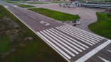
The Shorts SD3-30 airplane, a Part 135 cargo feeder flight operated by All Cargo Carriers (ACC), flew from Louisville International Airport (SDF) to Charleston Yeager International Airport, Charleston, West Virginia (CRW) early on the morning of May 5, 2017. Upon arrival, the captain flew the VOR-A, a non-precision approach to circling minimums and attempted to land on runway 5. The final approach course was offset 34 deg. from the landing runway. Close in to the airport, the captain attempted to land out of a 2,500-ft. per minute turning descent toward the runway in a steep left bank of up to 42 deg. The pitch attitude of the airplane decreased from -14 deg. to -5 deg. just before touchdown. The left wing struck the runway followed by the left main landing gear and the left propeller. The airplane careened off the left side of the runway, shed the left wing and slid down the steeply sloped forest that borders the airport. The airplane stopped at a point 380 ft. left of the runway centerline and 85 ft. below the runway elevation. Both pilots were killed and the airplane was destroyed.
CRW was the crew’s home airport. The ceiling was lower than the ATIS reported and the flight appeared to be in and out of the cloud bases during the approach. The captain was nearing the end of his second year of employment with the operator. The first officer (FO) was 5 months into her first professional flying job and had been paired with the captain since she was released to line flying.
The Approach
The airplane had no cockpit voice recorder (CVR), but FAA Air Traffic Control tapes recorded the flight’s radio calls.
The FO checked in with the CRW terminal approach controller at 0637, level at 9,000 ft. and in receipt of ATIS “November.” The 0554 weather observation reported wind from 080 deg. at 11 knots, visibility 10 statute miles, scattered clouds at 700 ft. AGL, a broken ceiling at 1,300 ft. AGL and an overcast sky at 3,100 ft. AGL. The temperature was 14C, dew point 13C, altimeter 29.41 and the localizer approach to runway 5 was in use. However, 7 minutes before the crew checked in with the approach controller, a special weather observation had reported an overcast layer at 500 ft. and a remark of valley fog.
The approach controller did not advise the crew of the new weather observation. He told the crew to expect the localizer approach to runway 5, which had an MDA of 1,320 ft. MSL and a height above touchdown of 373 ft. The FO then asked for the VOR-A circling approach, which had an MDA of 1,600 ft. MSL and height above airport of 619 ft. AGL. The controller approved the request, cleared the flight direct to the HVQ VORTAC and gave them a descent to 4,000 ft. MSL. At that time the airplane was aligned with the final approach course.
At 0642, when the airplane was 12 miles from HVQ, the controller cleared the flight to cross the VOR at or above 3,000 and cleared them for the approach. At 0646 the controller switched the flight to the tower controller. When the FO checked in, she stated they were on a visual approach, then corrected herself and said “VOR-A approach to runway 5.” CRW Tower reported the winds as 200 deg. at 5 knots and cleared the flight to land on runway 5.
At 0647:29 the tower issued a low altitude alert to the crew due to an automated alarm in the tower. They were at 2,200 ft. but descending rapidly. The controller told the crew the alarm may have been a false alarm due to excessive decent rate. At 0648:25 the flight leveled off at 1,600 ft. two miles outside FOGAG, which had a minimum depicted altitude of 1,720 ft. A ground witness saw the airplane “hugging the bases” of the clouds as it neared the airport. The airplane then began its steep descent, striking the runway at 0650:47.
Initially Findings
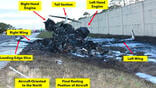
NTSB investigators found the first ground scar where the airplane's left wingtip impacted the runway 5 centerline was about 330 ft. from the displaced threshold and was oriented on a heading of about 016 deg. The left wing, left engine, left wing strut and left main landing gear were all found on the left side of runway 5. The remainder of the wreckage was in steep, wooded terrain well below the airport elevation. Flight control continuity was established and control system fractures were consistent with overload separation. The flap handle was in the 35-deg. detent and both control wheels were jammed in a full-right-turn position. Both propellers were found to have been rotating at about 1,400 rpm, flight idle with the prop levers full forward.
Investigators were faced with the fact that the accident airplane, operating under a Part 135 all cargo certificate, was not required to be equipped with either a flight data recorder (FDR) or a cockpit voice recorder (CVR). While aircraft recorded data is normally the best way to develop an accurate model of the airplane’s trajectory and the accident sequence of events, the investigative team was able to come up with alternative methods that worked well.
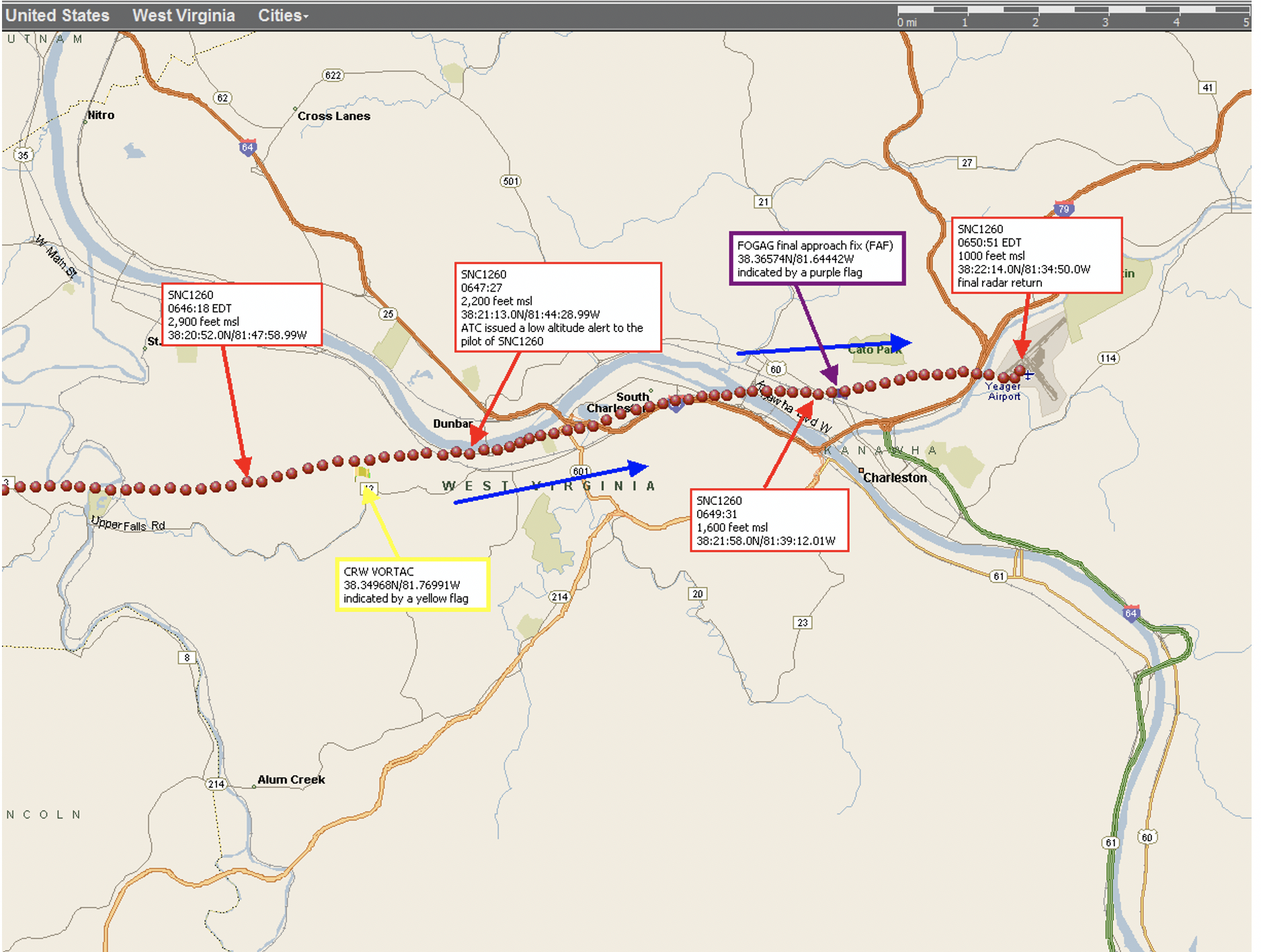
Using data from ATC secondary surveillance radar (SSR) records, a performance specialist was able to plot the location of the airplane overlaid on a Google map of the terrain and then calculate airplane airspeed, altitude, rate of climb and descent, pitch, bank and even load factor and angle of attack. A profile view of the approach from that study is shown in this figure.
Another specialist was able to estimate cloud height and airplane speed at touchdown by using video recordings from security cameras that captured portions of the accident flight. Using camera location, height and pitch angle, the specialist calculated the ceiling at the time the airplane first descended into view to be 683 ± 60 ft. above the airport ground level. He calculated the airplane’s speed at touchdown to be 92 ± 4 knots.
The investigator in charge used images from a DJI phantom drone equipped with a GPS/GLONASS receiver and camera to overfly the accident site and develop an orthomosaic image of it. He also used the drone to take pictures of the wreckage from above.
Editor's note: The NTSB's finding runs in a subsequent article.

Related Content