Is fuel planning for an oceanic trip just another mundane task you cede to your flight-planning service or does it force you back into a more primal stage of pilotage in which the details require extra scrutiny? Does a transatlantic trip from Westchester County Airport in White Plains, New York (KHPN), to Shannon, Ireland (EINN), prompt more steps than one to Los Angeles International (KLAX)? The latter will take more fuel and time, so why is the former any big deal?
As with many things in aviation, the answers to such questions depend on your level of experience, but not necessarily the way you think. I believe a more experienced international pilot will exercise greater caution, not less, than the novice.
For those with some oceanic experience, when you started “hopping the pond” your cockpit was probably cluttered with checklists to make sure you didn’t forget anything important because everything seemed important. As your comfort level went up, the number of checklists went down. Perhaps an example will not only illustrate the process, but also convince you of the importance of each item on what could very well be the most important oceanic crossing checklist.
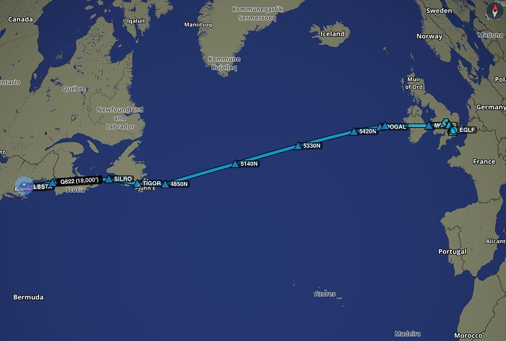
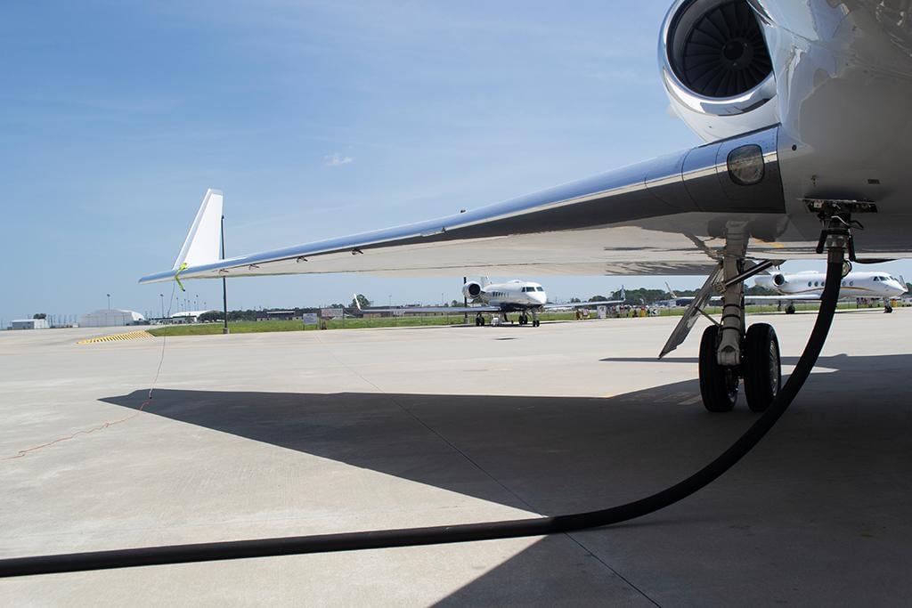
The distances are more extreme in the Pacific, to be sure. But nowhere in the world are there more complicating factors than in crossing the North Atlantic. So, let’s consider an easily flown trip from Bedford, Massachusetts (KBED), to London Farnborough (EGLF), in a Gulfstream G500.
Step One: From Point A to Point B
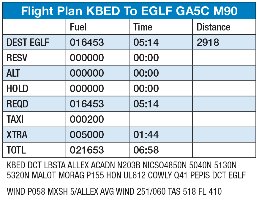
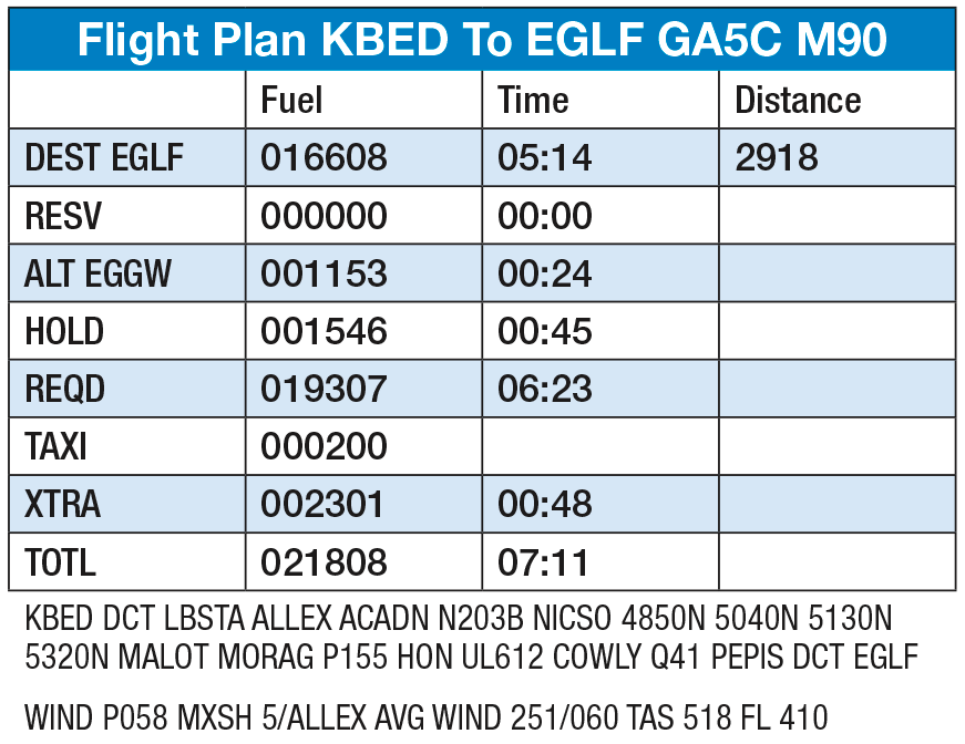
Fuel planning for an oceanic trip starts just like it does for one over land. You run a flight plan from point A to point B, taking into consideration the fuel needed for engine start, taxi out, takeoff, climb, cruise, descent, landing and any reserves required by regulations and your company SOPs. In the case of our example flight, we would type into our flight-planning software our desire to climb at Mach 0.87, cruise at FL 430 doing Mach 0.90 and land with 5,000 lb. of fuel.
In just a few seconds we discover the airplane can do all this at FL 410 and it will take 16,453 lb. of fuel. So, adding our 200 lb. of taxi fuel and 5,000 lb. of desired fuel on landing means we need to load 21,653 lb. of Jet-A total. Easy. It’s pretty much a straight shot. Right? Not so fast. Let’s say the weather at Farnborough requires an alternate.
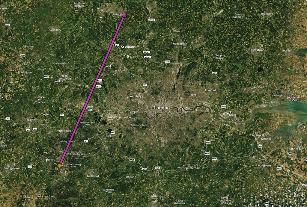
Step Two: Destination Alternate
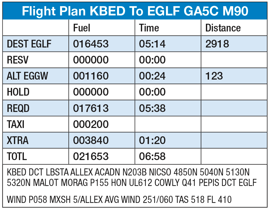
It is just a matter of finding the right box and typing. London Luton (EGGW), is a pretty good choice: The airport handles business jets and has airline service, the roads into London are pretty good and it is just 39 nm to the north of the city as the crow flies. Unless you are a crow, however, that direct routing is just about impossible.
Depending on your flight-planning software’s defaults, as the crow flies may be exactly what you have planned and that could be a rude shock as you look at your fuel gauges after toggling the Take Off/Go Around (TOGA) function of your flight director. Even if fuel isn’t a concern, a Safety Assessment of Foreign Aircraft (SAFA) inspector will be looking for realistic alternate fuel numbers on your flight plan.
A good way to anticipate missed-approach routing is to look at any standard instrument departures from your arrival airport and any standard arrivals into the alternate airport. Most flight-planning service providers will do this for you automatically, but you may have to specify this in your account configuration. As a matter of fact, the expected routing to our missed approach alternate is quite a bit farther than what that crow would have flown.
It may seem strange that this didn’t change our total fuel required at all, but notice the alternate fuel was subtracted from our 5,000 lb. on landing at Farnborough.
So, we have fuel computed from takeoff to destination, as well as a missed approach at our destination and the expected routing followed by an instrument approach and landing at our alternate. Job done. If this were a trip across the U.S., it would be. But what if we have some kind of problem en route?
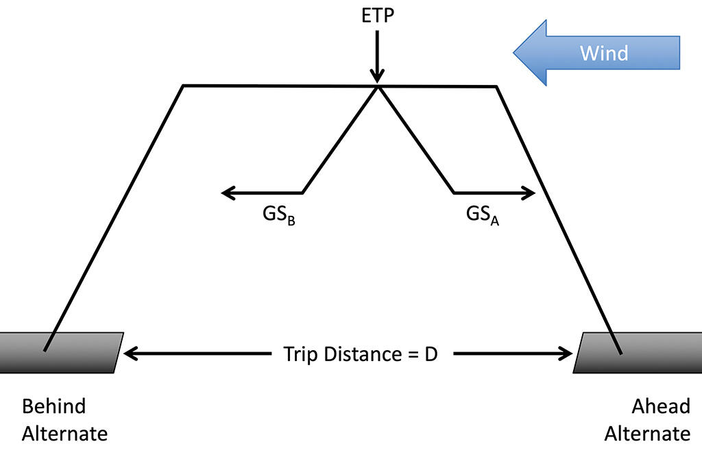
Most of us understand what an equal time point is and that the math is fairly straightforward. We know that our divert decisions are based on where we are in relation to one or more equal time points. We long ago gave up the math. Now, we simply assume the latitude and longitude of the ETPs shown in our flight plan have our best interests in mind.
The formats differ among providers and there is more than one type of ETP; but let’s consider the ETP given an engine failure. It is important to realize that in the phrase “equal time point” there are two contradictory meanings. First, an “equal time” is a time given in hours and minutes. Second, “point” is a location in space, given in latitude and longitude. Here we see two ETPs that can lead to three different decisions.
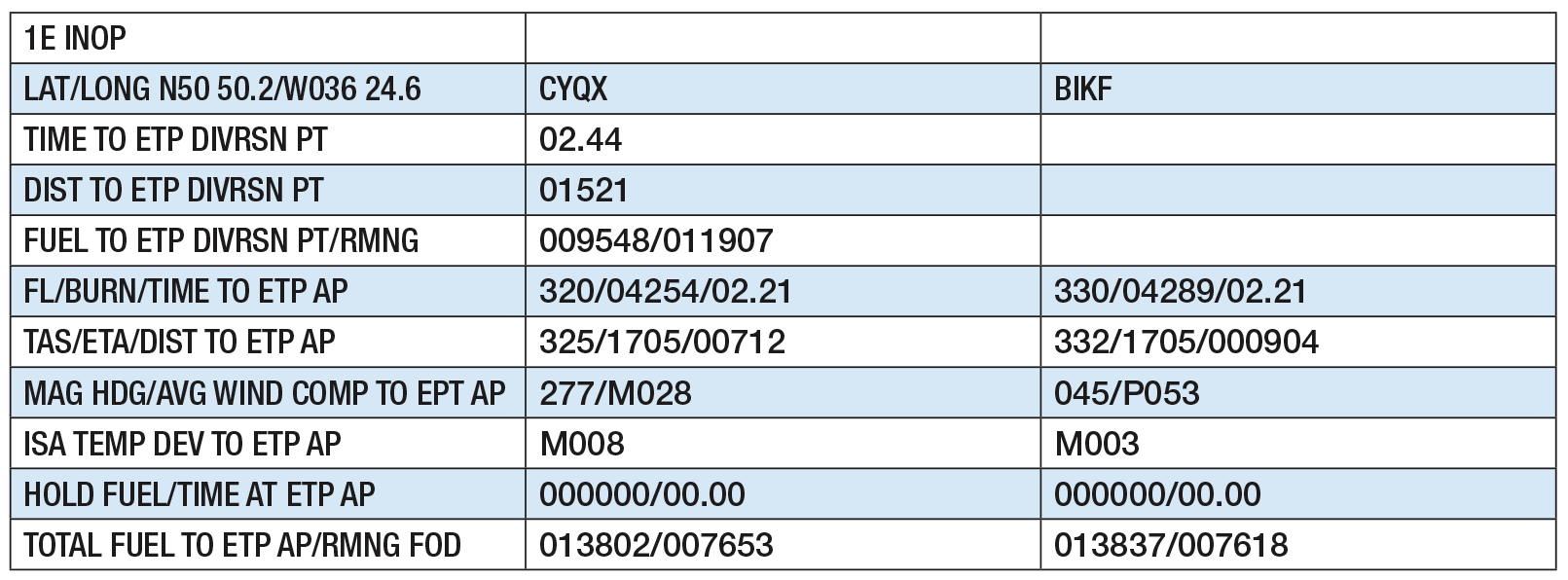
The first point, given at 36 deg., 24.6 min. W long., is a point in space at which we’ll arrive 2 hr. and 44 min. after takeoff. If we have an engine failure at this precise location, it will take us 2 hr. and 21 min. to fly on the remaining engine and at our best single-engine cruise altitude to get to Gander, Newfoundland (CYQX), or to Keflavik, Iceland (BIKF). The times are equal. If we have an engine failure before this point, it will be faster to turn back to Gander.
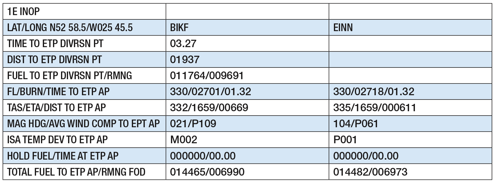
The second point, given at 25 deg., 45.5 min. W long., is another point in space that we will get to 43 min. later. If we lose an engine at this point, it will take us 1 hr. and 32 min. to turn to Keflavik or to press on to Shannon. The times are equal again, but different than the first set of times. If we lose an engine prior to this point but after the first, we head to Keflavik. After this point, it is faster to head for Shannon.
So, if we have an engine failure at 30 deg. W, we turn left to Keflavik. We usually train for this by doing an engine-out drift down: Set the operating engine(s) to a maximum allowed for continuous operation, allow the speed to decrease to an optimal figure, and then slowly descend in a bid to maximize forward distance against altitude loss. This can be as little as 500 fpm but is more typically around 1,000 fpm. Thus we are doing everything possible to increase our chances of a safe diversion. At least that used to be true. Let’s look at another factor.
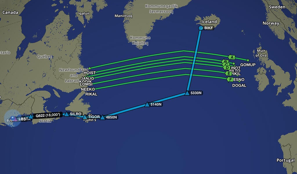
Let’s say on this particular time and date, the westbound North Atlantic Tracks are active and between us and our Keflavik ETP airport. Our reaction to this used to be like this: We are the emergency aircraft, everyone else can get out of our way. You don’t climb your way up the ranks of professional pilots and end up as an international jet pilot without knowing you need to maintain a listening watch on guard, so the risks are small.
If you still think this way, let me offer the following as a hypothetical. Let’s say one of those airplanes on a westbound track that you are about to drift through is an Airbus A330 carrying a crew of 12 and 228 passengers. Let’s also say the only experienced pilot on the airplane is in back during a permitted rest period and up front you have two first officers, the most experienced of whom has 7,000 hr. total time and the pilot flying the airplane has about 3,000 hr. Both have less than six years of experience with the airline and about half of that flying oceanic. Those were the circumstances aboard Air France Flight 447 in 2009 when the two pilots up front didn’t know what to do when the autopilot disconnected at 35,000 ft. and they ended up stalling the airplane right down to the ocean, killing everyone on board.
You may think the odds of this kind of crew component has decreased since then, but it has been just the opposite. So, does that change your decision making when deciding to cross the tracks? What are the odds those two youngsters are faithfully listening to guard channel?
The correct answer, in my book, is to descend below the tracks before you get to them. My flight-planning service doesn’t figure for a drift down in fuel planning but does compute a straight line. If I were headed north, I doubt I would end up on a straight line while trying to get below the tracks. I would add fuel to allow for the maneuvering. Or I might consider another option.
Lajes Airport in the Azores to the south is often a good option, depending on the weather. In this case, flying a straight line south doesn’t take much more gas than the northerly option. But the chances of getting to fly that straight line are higher. Sometimes the tracks are north of you, sometimes they are south of you. This is something you have to consider the day of the flight, since the people placing those tracks are only doing so half a day earlier.
Many flight-planning service providers default to zero holding time at ETP airports in an effort to minimize the fuel burn. But what are the odds you are going to be permitted to bust right into the traffic pattern at your ETP alternate and immediately land? You are an emergency aircraft. But does the weather care? It might be a wise idea to plan on some holding fuel here.
This doesn’t necessarily mean you are going to have to carry more fuel, but you might. I recently saw a flight plan for a Bombardier Challenger 605 from Onizuka Kona International Airport, Kona, Hawaii (PKOA), to John Wayne-Orange County Airport, Santa Ana, California (KSNA), that planned on only 342 lb. of ETP fuel in the event of a depressurization. I’ve seen Gulfstream G550 polar flight plans with less ETP fuel than that. Your service may not flag this kind of planned minimum fuel, so it is up to you to check. In the case of our example flight to London, it actually takes less gas to get to our ETP alternates than it does to get to our destination, so we are good.
Now, finally, we have enough fuel to taxi, take off, make an approach at our destination, go missed, make another approach and land at our alternate; and we know that we can divert en route while oceanic to one of three different ETP airports. Perfect, right? Well, not yet.
Step Four: Reserve Fuel
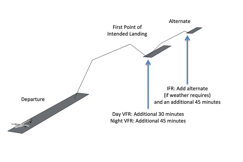
A 14 CFR Part 91 operator flying under IFR rules must have enough fuel to make it to the destination plus enough for an additional 45 min. at normal cruising speed. If an alternate is required, you must have enough juice to make it to your destination, shoot and miss the approach, and fly to the alternate, plus an additional 45 min. at normal cruising speed.
Step Five: Maintaining Altitude and Mach
Your company’s rules might add even more fuel. Ours doesn’t, so in the end we are going to need 21,808 lb. to meet all requirements. That gets us to our destination with 5,000 lb., our ETP alternates with more than that and our destination alternate with less. If we show up on the day of the flight and find the airplane has 4,000 lb. of Jet-A in the tanks, how much fuel do we need to upload?
We could estimate, saying we want about 22,000 lb. After all, we have 4,000 lb., so we need to upload 18,000 lb., which comes to 1,800 gal. plus half again, or 900. So, we ask the fuel truck driver for 2,700 gal.
Now, be honest, when the fuel truck driver asks you “How much?” are you really going to say 2,700 gal.? Or is something inside you tempted to say 2,800?
There is an old Air Force saying that goes like this: You can never have too much gas, long pause, unless you are on fire. Commercial aviators will add: . . . or unless you are too heavy to land at your destination. Let me add something for oceanic flight: . . . or unless you are too heavy to maintain altitude and Mach over water. Let’s look at a typical day over the North Atlantic on our way to London.
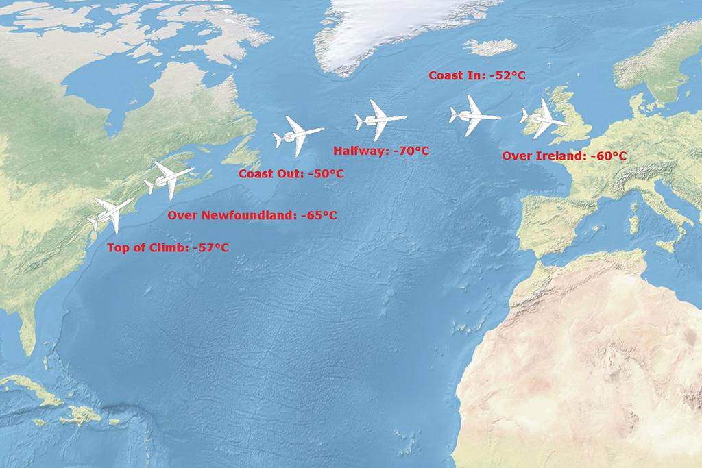
Your temperature most of the year at top of climb heading to Newfoundland will be around -57C. What’s another term for that? ISA, that’s a standard temperature day at high altitudes. In the case of our G500, the airplane shoots right up there and has a comfortable airspeed and thrust margin. No problem, right?
Flying farther north over Newfoundland you might even see the temperature drop to -65C. That means it takes less thrust to maintain Mach and you might even be tempted to climb. The flight plan was based on 41,000 ft. but you really wanted 43,000 ft. You would be wise to resist that temptation.
Just after coast out, -50C isn’t typical but it isn’t uncommon, either. A swing of 15 deg. in less than an hour can seem like a cruel joke, but it happens over the North Atlantic all the time -- in fact this is typical. If you climbed an extra 2,000 ft. you might find yourself needing to request lower. If you loaded an extra 2,000 lb. of fuel, ditto. Over the years I’ve heard at least a dozen aircraft on the radio begging for lower because of this. I’ve heard two cases of aircraft declaring an emergency because they were getting close to the stall and air traffic control denied their request for lower because the tracks below were taken.
After you’ve burned off some fuel you might be able to request and receive clearance for a climb. In fact, halfway across it isn’t unusual to see the temperatures drop quite a bit. These days with data link, if you are flying above the tracks, getting a climb or speed change is not too hard.
It should be noted that you will have the exact same situation coming the other way. Temperatures over Ireland can be at ISA or lower. But just west of Ireland you can see the temperature climb a good 10 deg. or more.
Putting It All Together
The lesson here is clear: If you are tempted to add a few hundred gallons of fuel, keep in mind the impact it will have on your ability to make your cruise altitude and then to hold it once you are there.
So, the steps when it comes to flying oceanic begin the same way they do when flying domestically. You have to get to your destination with enough fuel to fly an approach, go missed approach, and then shoot another approach and land at your alternate with adequate reserves. What’s adequate? Typically that is an additional 45 min. of flying time. This fuel might be enough to safely get to your oceanic equal time point alternates, but it might not. It is up to you to examine each ETP scenario to make sure the fuel is adequate for routing that keeps you out of the way from other traffic and gets you to where you need to be.
And the last point to remember: There is a minimum fuel to get the job done, but there is also a maximum fuel to consider. What happens when the minimum is too high or the maximum is too low? Sometimes you’ll need to cancel the trip.

Related Content