U.S. Government Releases More Shuttle Radar Terrain Elevation Data
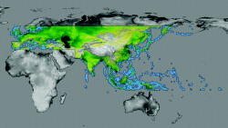
The U.S. Geological Survey has released another batch of terrain elevation data collected in February 2000 by the crew of the space shuttle Endeavour on the Shuttle Radar Topography Mission (SRTM). The area covered in the latest release stretches from the U.K. to the islands of the Pacific, and...
Subscription Required
This content requires a subscription to one of the Aviation Week Intelligence Network (AWIN) bundles.
Schedule a demo today to find out how you can access this content and similar content related to your area of the global aviation industry.
Already an AWIN subscriber? Login
Did you know? Aviation Week has won top honors multiple times in the Jesse H. Neal National Business Journalism Awards, the business-to-business media equivalent of the Pulitzer Prizes.
Related Content