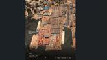
Maxar is looking to use its satellite imagery database to help improve drone operations in GPS-denied settings.
Credit: Maxar
Earth observation provider Maxar Intelligence is getting into the business of providing precision navigation information in GPS-denied conditions as part of the company’s wider push to branch out beyond providing satellite imagery. The new product effectively allows users to fuse drone full-motion...

Subscription Required
Maxar Enters Denied-GPS Market is published in Aerospace Daily & Defense Report, an Aviation Week Intelligence Network (AWIN) Market Briefing and is included with your AWIN membership.
Already a member of AWIN or subscribe to Aerospace Daily & Defense Report through your company? Login with your existing email and password.
Not a member? Learn how you can access the market intelligence and data you need to stay abreast of what's happening in the aerospace and defense community.
Related Content