NASA’S Aqua Satellite Pinpoints Los Angeles Wildfires
Credit: NASA
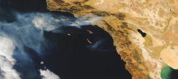
The Moderate Resolution Imaging Spectroradiometer (Modis) on NASA’s Aqua satellite continues to demonstrate its value as an aid to officials responding to natural disasters, as illustrated by this Nov. 16 image of the Los Angeles basin ringed by wildfires. Both the National Oceanic and Atmospheric...
Subscription Required
This content requires a subscription to one of the Aviation Week Intelligence Network (AWIN) bundles.
Schedule a demo today to find out how you can access this content and similar content related to your area of the global aviation industry.
Already an AWIN subscriber? Login
Did you know? Aviation Week has won top honors multiple times in the Jesse H. Neal National Business Journalism Awards, the business-to-business media equivalent of the Pulitzer Prizes.
Related Content