Canada Maps Arctic Territory with Decade-old SAR-Imagery Pairs
Credit: VEXCEL CANADA
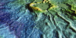
Vexcel Canada, an Ottawa-based remote sensing company, has used 10-year-old data from ESA's ERS-Tandem mission to map elevations on Baffin Island and elsewhere in the territory of Nunavut with unprecedented accuracy, demonstrating the long-term utility of space-derived data sets. Vexcel has produced...
Subscription Required
This content requires a subscription to one of the Aviation Week Intelligence Network (AWIN) bundles.
Schedule a demo today to find out how you can access this content and similar content related to your area of the global aviation industry.
Already an AWIN subscriber? Login
Did you know? Aviation Week has won top honors multiple times in the Jesse H. Neal National Business Journalism Awards, the business-to-business media equivalent of the Pulitzer Prizes.
Related Content