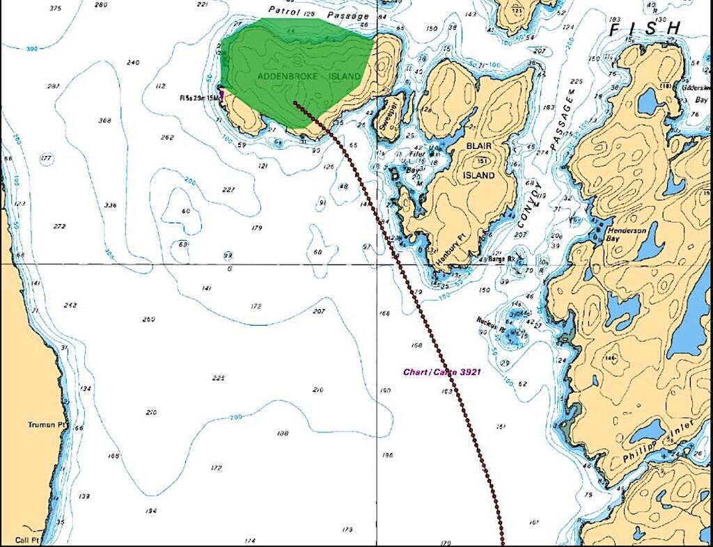
G1000 Base map and actual land mass of Addenbroke Island, British Columbia
Airports along British Columbia’s central coast are widely spaced. Ole’s Fishing Lodge was located 66 nm north-northwest of Port Hardy Airport (CYZT) and 29 nm southeast of Bella Bella (Campbell Island) Airport (CBBC). Weather reports from these airports are of limited value to pilots going to remote destinations because of the distances between them and the highly variable coastal weather. At the time the Seair pilots flight-planned, reports from CYZT and CBBC were marginal but within minimum regulatory requirements.
The graphic area forecast (GFA) and the local graphic forecast (LGF) were more appropriate weather sources for the flights, and they were less favorable. According to the two forecasts applicable at the time, conditions for the last 75 nm of the flights were overcast with occasional moderate rain showers, patchy cloud ceilings as low as 600 ft. AGL, isolated thunderstorms, and localized rain and mist with ceilings as low as 100 ft. AGL and visibilities as low as 1/4 sm.
Multiple staffed lighthouses along the coast also provided reports. The Addenbroke Island Lighthouse station was reporting 1 1/2 sm visibility, light rain and fog, 800 ft. overcast, and southeast winds at 17 kt. at 0730.
Thirty minutes before the accident, weather cameras in the vicinity of the flight were indicating low ceilings and visibilities between 0.6 and 1.4 sm. After the accident, flight crews reported they had encountered visibilities near Addenbroke Island of 1/2 sm or less.
Until the last 8 min. of the flight, the accident aircraft was within radio range of the Port Hardy flight service station and could have obtained updated weather reports before continuing. Diversion airports were available at Comox, Campbell River and Port McNeil, and a fishing lodge at Rivers Inlet only 14 nm from Addenbroke Island was available. It had been mentioned during the morning briefing.
Canadian air regulations provide that an airplane in day VFR flight in uncontrolled airspace operating below 1,000 ft. AGL must maintain at least 2 sm visibility and remain clear of clouds. The regulations also require that VFR flights may not operate lower than 300 ft. AGL or closer than 300 ft. from any obstacle in daytime, except during takeoff or landing.
As the accident pilot continued his descent toward Addenbroke Island, he ignored these regulations.
Seair pilots used a company-developed weather policy decision tree to aid in making go/no-go departure decisions. If weather was forecast to be below minima during flight, the decision tree did not automatically recommend cancellation. Instead, pilots were allowed to use other criteria, including inflight information, to make the decision to go. The policy recognized that highly variable and patchy weather conditions were part of the environment. However, the Transportation Safety Board of Canada (TSB) found that group dynamics affected decision-making at Seair and advised that group dynamics may result in conformity, compliance and groupthink.
On the morning of the accident, the group of pilots included the company president and the director of operations. While one pilot declined to fly, the others decided to depart even though the forecast was very questionable. Later, when the accident pilot was in flight, his decision to continue was influenced by the southbound pilot, who was the director of operations.
In its analysis, the TSB expressed concern about the company’s culture of accepting unsafe practices. It cited the accident airplane’s overweight takeoff, the placement of oversized cargo in the passenger compartment, the accident pilot’s continuous use of autopilot below 800 ft. AGL and his use of a cell phone during flight. The company did not routinely record pilot in-flight policy compliance and did not have a flight data monitoring program to evaluate whether pilots routinely followed procedures.
Findings, CFIT and PAVE
Rather than issue a probable cause, the TSB issued four findings as to cause and contributing factors. Paraphrased, they were:
- The flight departed even though the weather was below VFR minima, and the decision was probably influenced by senior staff.
- The pilot continued flight when visibility fell without recognizing his proximity to terrain.
- The G1000 terrain alerting system and its color ambiguity were not effective in alerting the pilot about the terrain ahead.
- The pilot’s attention, vigilance, and general cognitive functions were probably influenced by fatigue.
As with British Columbia, Alaska has also experienced many CFIT accidents. Since 2013, aircraft in Alaska have experienced 17 CFIT fatal accidents, of which 11 involved Part 135 aircraft.
The U.S. NTSB has recognized that TAWS devices as currently designed do not provide protection for aircraft operating below 700 ft. AGL and has issued a safety recommendation (A-17-35) to the FAA to address the issue. The FAA says it is working on an improvement to the design of TAWS.
Although the TSB did not cite the FAA’s PAVE flight risk management acronym, it neatly describes the risks the pilot experienced in this accident.
“P” is for pilot. The pilot was at risk because of chronic fatigue and a lack of simulator training for low altitude hazard recognition.
“A” is for aircraft. The airplane was at risk because its terrain awareness device was unsuitable for the low altitude and was turned off.
“V” is for environment. The weather forecast was too low, and the pilot departed and persisted in flying despite adverse conditions.
“E” is for external factors. The pilot allowed himself to be influenced by an unsafe group decision and pressure to continue.
There are risks in every flight. Knowing when to acknowledge the risks and change plans is the key to completing the flight safely.
Too Low: A Cessna Caravan Crashes Into Terrain, Part 1: https://aviationweek.com/business-aviation/safety-ops-regulation/too-lo…
Too Low: A Cessna Caravan Crashes Into Terrain, Part 2: https://aviationweek.com/business-aviation/safety-ops-regulation/too-lo…

Related Content


Comments
Corrective actions should require the pilots at Seair to maintain instrument currency and for Seair to develop IFR escape routes if weather conditions deteriorate enroute. Otherwise the company's "culture" predisposes pilots to descend into danger in order to remain VFR.