On Oct. 29, 2012, a 13-ft. storm surge from Superstorm Sandy flooded large portions of Teterboro Airport (KTEB). In addition to submerging significant portions of the runways and taxiways, several buildings and extensive amounts of electrical infrastructure also sustained damage. Once the storm surge subsided, airport authorities and businesses had to deal with the mass damage in the surrounding boroughs just to get workers and heavy equipment on scene to repair the damaged infrastructure.
It isn’t just the New York City airports that have suffered significant damage from storm surges. Typhoon Jebi in September 2018 generated a storm surge of almost 11 ft. at Kansai International Airport (RJBB) in Japan, sending waves crashing over the airport’s seawalls and swamping its pumps. An oil tanker whipped around by the storm’s 130-mph winds damaged the only bridge connecting the island to the mainland. Eight thousand people were trapped in the airport’s terminals for over 36 hr., darkened without electrical power, as waves continue to pound the buildings’ walls.
Typhoon Goni closed the runways at Shanghai Hongqiao International Airport (ZSSS) in 2015. Passengers had to “teeter” across an improvised bridge of chairs and tables trying to reach dry ground.
Similar events on U.S. military installations have caused immense damage. In September 2018, the Marine Corps’ Camp Lejeune was severely damaged by Hurricane Florence and subsequent flooding of North Carolina. The Commandant of the Marine Corps, Gen. Robert Neller, told the U.S. Senate Armed Services Committee that the projected costs to repair the damage to this single military facility would be $3.6 billion. Only a month later, in October 2018, Tyndall AFB, Florida was hammered by Hurricane Michael. Previously home to many of the Air Force’s F-22s, rebuilding will likely take years and cost upward of $4.5 billion.
An analysis by the Airports Council International finds that one-quarter of the world’s 100 busiest airports are less than 32 ft. above sea level. Twelve airports, including Shanghai, Rome and San Francisco, are less than 16 ft. above sea level, making them prone to Mother Nature’s thrashing from the combined threat of sea level rise and storm surges.
Long ago, low-lying areas along the water were considered ideal building sites for new runways because there are few obstacles to obstruct initial climbs and less potential for noise complaints. However, these locations often have few natural protections against flooding or high winds. KTEB faces near-complete inundation with as little as 3 ft. of sea level rise (SLR). Many of the roadways and communities around it face inundation at 3 and 6 ft. Newark Liberty International (KEWR) and LaGuardia (KLGA) airports can withstand 3 ft. of SLR but are vulnerable to 6 ft. JFK International Airport (KJFK) is able to withstand both 3 and 6 ft. but will need to be hardened for future storm surges.
SLR is primarily driven by two factors. The first factor is “thermal expansion”--as ocean temperatures rise, the water expands. The second factor is melting of land ice (ice sheets and glaciers), which adds water to the world's oceans. Sea levels are predicted to rise broadly with the global average over the long term. Under the medium to low carbon emissions scenario, many parts of Europe are predicted to experience an increase in sea level of more than 0.4 m by the end of this century. A rise of 1 m would put 96 European airports at risk of inundation, according to the EU’s Joint Research Center.
A second factor threatening coastal airports comes from storm surges associated with tropical storms and hurricanes. According to the National Hurricane Center, storm surge is an abnormal rise of water generated by a storm, over and above the predicted astronomical tides. Storm surge should not be confused with storm tide, which is defined as the water level rise due to the combination of storm surge and the astronomical tide. This rise in water level can cause extreme flooding in coastal areas particularly when storm surge coincides with normal high tide, resulting in storm tides reaching up to 20 ft. or more in some cases.
These effects are exacerbated when combined with excessive precipitation, which can lead to excess flooding where run-off collides head-on with storm tides. This merging of factors caused the extreme floods in Myanmar during Tropical Storm Nargis in 2008.
When water levels rise from a combination of these sources, there will be damage to infrastructure, especially buried infrastructure such as electrical lines, sewage and water delivery. Loss of ground transport access from storm surges will occur when roads become flooded, delaying delivery of badly needed repair teams. Nearby rail lines providing transport of heavy goods can suffer damage that will require extensive and costly repair that isn’t done overnight.
Subsiding Soils Make This Worse
The National Intelligence Council (NIC) is concerned that more than 30 U.S. military installations already are facing elevated levels of risk from rising sea levels. According to the DoD’s “Report on Effects of a Changing Climate to the Department of Defense,” Navy Region Mid-Atlantic and the greater Hampton Roads area is one of the most vulnerable to flooding in the U.S. This region includes Joint Base Langley-Eustis, Virginia, which has experienced 14 in. in water level rise since 1930 due to localized land subsidence and SLR. It currently is only 3 ft. above mean sea level elevation, thus flooding has become more frequent and severe.
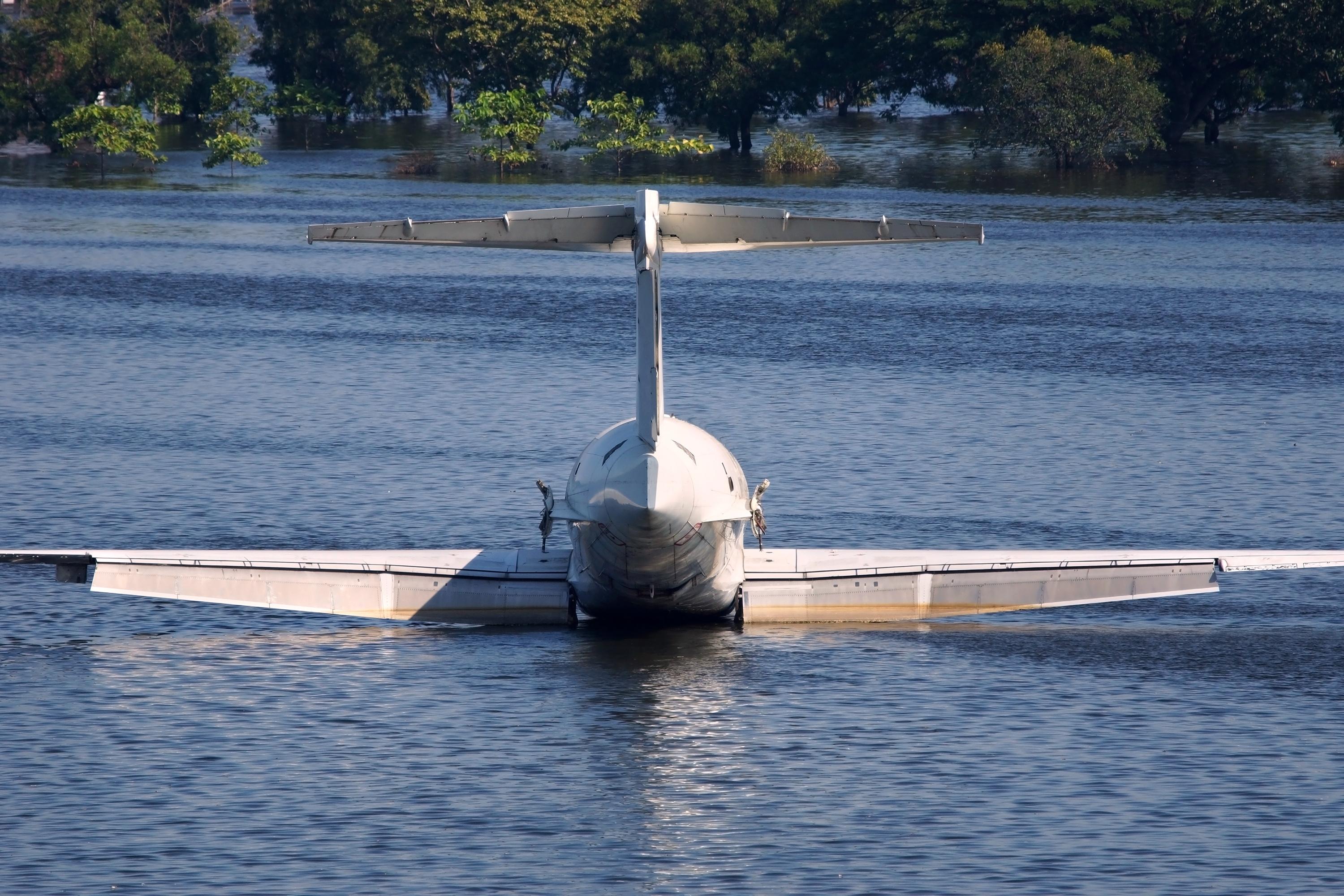
Kansai Airport, which serves Osaka, Kyoto and Kobe, sits on a man-made island 3 mi. offshore. It was built over a decade from the equivalent of two mountains of gravel and sand. Building the airport in the bay was necessary not only to minimize noise problems but also to avoid vocal protests over land rights. Civil engineers expected the island to sink at the rate of less than a foot per year over 50 years as the seabed settled under the airport’s weight. However, the island sank more than 30 ft. in its first seven years. It is presently 43 ft. lower than its original elevation and continuing to sink. Civil engineering professor Gholamreza Mesri from the University of Illinois at Urbana-Champaign predicts at least one of the airport’s two runways will be completely under the current sea level by 2058 based solely on this subsidence. With sea levels rising due to climate change, the airport will be underwater even sooner. In his words, “You won’t have an airport, you’ll have a lake.”
Runway Protection From Flooding
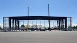
In the aftermath of Superstorm Sandy, public safety authorities have been trying to prevent the loss of vital infrastructure in the future. In 2013, airport authorities at KTEB installed a protective flood barrier around the airfield lighting vault, an emergency generator and a diesel tank used for fueling airport vehicles. LaGuardia, with the help of a $28 million federal grant, added a flood wall, rainwater pumps and a new drainage system, and upgraded its emergency electrical substations and generator.
Building enhanced sea defenses to protect airports susceptible to SLR involves much more than simply dumping a lot of big rocks to build a protective structure around the runways. While rock walls may provide partial protection from storm surge around a runway, the soils directly under a runway may act as a sponge soaking up water. A rising water table can cause flooding waters to seep up from below, causing near-term flooding. In the long term when clay soils under runways are exposed to water, the differential contraction and expansion of those soils will buckle runway surfaces.
Norwegian authorities have been conducting a risk assessment of its 46 airports that are scattered along the rugged coastline. Twenty of them are quite exposed and several have runways less than 4 m above sea level. The seabed close to some runways is very deep and would have a huge impact on “stormproofing” the safety areas. A risk assessment by Avinor for each airport included calculations accounting for future sea levels, wind directions, wave directions and underwater topography (all of which interact with each other) to calculate the size, shape and amount of rock fill needed to make robust safety embankments that would be able to withstand future storms.
Authorities in charge of the addition of a new runway at Australia’s Brisbane Airport (YBBN) conducted similar analyses. The proposed runway site is currently subject to inundation during high tide, flood events and at risk to future climate change impacts such as storm surge and SLR. The project required the services of the Antarctic Climate and Ecosystems Collaborative Research Centre based in Tasmania, Australia, to evaluate the runway height specifications using the latest climate and sea level data available. The ACE CRC recommended the runway design level (5.2 m above the current mean sea level). This required construction of tidal channels and installation of a new sea wall. Thankfully this happens to be the same height as the existing runway so there will not be an undesirable incline (gradient) along the linking taxiways and links into adjoining aprons.

Related Content