Innovation is often cited as native to the American character. The ability to recognize an opportunity and exploit it with a unique idea has been the cornerstone of American progress for more than two centuries and remains the driving impulse behind today’s tech revolution.
In 2006, the principals behind the Iridium satellite telephone enterprise came up with an innovative idea: Lease excess capacity on its planned second-generation communication satellites to host the payloads of others looking for a global perspective from space. Among the entities they investigated were various U.S. government agencies including the FAA, where they learned of an interest in hosting an air traffic control payload aboard orbiting satellites and that Automatic Dependent Surveillance-Broadcast (ADS-B) had become the paradigm for ATC on the ground.
Further, mandates existed around the world to equip aircraft with ADS-B avionics, and new aircraft were rolling off production lines with the avionics already installed and certified for use. There was also a need to provide ATC in remote regions where ground infrastructure like radar or even ADS-B ground stations were nonexistent. It was a “light-bulb moment” for Iridium: With 66 satellites in low-Earth orbits (LEO) of 484 sm (780 km) altitude, it could provide global coverage. Not only that, but the satellites were designed to interlink—that is, they could pass signals among them without having to relay to the ground, obviating the need for ground stations. This made them useful over remote territory or oceans, facilitating true global coverage.
Discussions commenced with the FAA, Nav Canada, NATS in the UK, and other air navigation service providers (ANSPs). Then in 2012, Iridium and Nav Canada formed Aireon LLC, with the latter contributing $150 million for a 51% ownership. The new entity proceeded to raise $202 million more in equity by signing additional partners the Irish Aviation Authority (IAA) for a 6% ownership, Italy’s ENAV (12.5%) and Denmark’s Naviair (6%). (Additionally, in 2018, Aireon signed a $200 million credit facility with Deutsche Bank.) Aireon moved forward, using the additional capitalization to build the ADS-B components for Iridium Next satellites, which the satcom company was scheduled to begin launching in late 2015.
Global Coverage—Even in Antarctica
Altogether, it took eight launches over two years to put up 66 satellites plus six spares (with nine more stored on the ground), replacing the original Iridium constellation launched in the 1990s. The primary launch vehicle was the Space X Falcon 9, while the first two liftoffs were aboard Russia’s Kosmostras Dnepr rockets. The satellites were distributed 12 each among six orbital planes, traveling at 16,777 mph (27,000 kph). Because satellite coverage overlaps, there are no voids, and ADS-B reception is now available anywhere in the world, even in Antarctica. Receivers aboard the satellites listen on the 1090 MHz ADS-B frequency, meaning any aircraft outfitted with ADS-B avionics can access them. L3Harris Technologies oversees Aireon’s ground-based facilities, controlling them from its center in Herndon, Virginia. Meanwhile, Iridium is responsible for controlling the satellites out of its center 13 mi. away in Leesburg.
Following the final launch in January 2019, Iridium began certification of the satellite constellation after which Aireon and its customers commenced a testing phase of the ADS-B function. (Just as a footnote, think of the magnitude of this endeavor: Sixty-six satellites had to be lofted into their designated orbits and positioned at the proper distance from one another, then turned on and interlinked with each other and the ground, and, finally, the ADS-B payloads all had to awaken and begin accepting aircraft positions. Despite the challenges, it all went flawlessly.)
“All that was completed in March 2019 when we went active,” Aireon CEO Don Thoma told BCA. “That was the global rollout.”
As of today, 18 ANSPs including Eurocontrol have signed onto Aireon or are in the evaluation process. (At this writing, it was 16 plus two in the process of joining. See “Aireon Customers” sidebar for a full list.) Many represent multiple countries, and when looked at that way, there are 38 beneficiaries of the space-based system. With the exception of Eurocontrol, which is using Aireon satellite-based ADS-B as a data source for air traffic flow management, all of the ANSP customers are using the service for ATC surveillance.
“With the contracts we have signed and are in the process of implementing,” Thoma said, “we were on schedule to be profitable this year—that is, prior to the COVID-19 pandemic. So we are drawing down the Deutsche Bank credit to keep operating. No users have pulled out, which shows the uniqueness of this capability and that it has a place in the ATC infrastructure in any financial environment. We pulled together many ANSPs around the world to deploy the capability and share how they can use it to everybody’s benefit. It has been a collaboration.”
Aireon is a new model for the ANSPs, Thoma maintains, “in that, instead of operating their own systems, they are buying into the space-based service. Because it is a safety-oriented function, we had to implement secure data circuits in the ANSPs. Actually, this is a fairly simple process, as it fits into their systems easily.” In fact, it is a simple rack of equipment that plugs into the ANSP’s system, followed by certification testing.
“Of course, it has to have a high fidelity of operation,” Thoma continued. “Every time we implement a service with a customer, we go through a service-acceptance test, a revaluation of the service to ensure it performs to defined levels of service metrics. We monitor it from our control/data center in Ashburn, Virginia, plus an operations center at L3Harris in nearby Herndon and a second one at our headquarters at Tysons Corner (Virginia). We provide transparency to the operation of our system. If there is an issue, we can respond very quickly and report it immediately to our customers. We also operate some equipment—the payloads on all the Iridium satellites —out of the Iridium ops center in Leesburg.”
The FAA is an Aireon customer, too, currently running an operational trial in Caribbean airspace. “We worked with the FAA under an MOA for many years, starting in 2011 [the genesis of the project],” Thoma said, “sharing with the FAA our plan and they with us their experience with ADS-B, and over time, that relationship evolved as we finalized our designs and conducted critical reviews, and the FAA was with us all the way through that process. They also volunteered their aircraft for testing our system over the Atlantic and in some terrestrial airspace.”
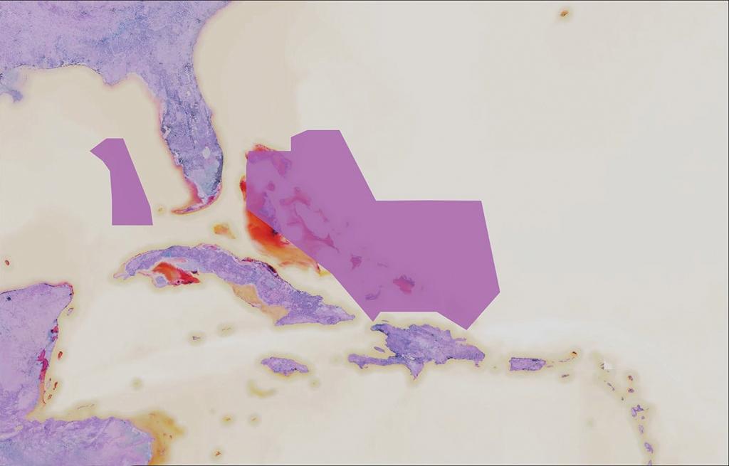
As part of its relationship with the FAA, Aireon was granted contractual authorization from the agency to purchase Miami Oceanic Airspace to support operational use of ADS-B beginning in August this year. Meanwhile, upgrades are in progress to ATOP (Advanced Technologies and Oceanic Procedures) for deployment into the oceanic regions of the U.S.
How Effective Is It?
Aireon had only a year of “normalcy” to prove itself as a useful adjunct to air traffic management — that is, from its activation in March 2019 to the global lockdown in March 2020 in response to the COVID-19 pandemic and the consequent precipitous worldwide decline in air travel. During that relatively brief introduction, what did the aviation community learn about the effectiveness of the space-based ADS-B program?
“When traffic is booming,” Thoma said, “Aireon provides efficiencies, and even in a downturn, it provides more alternatives. It can supplement ground-based systems or even replace them, so that in a downturn, ANSPs can discontinue using expensive radar in lieu of using space-based surveillance. Secondly, in this kind of environment [the pandemic], where there are lockdowns, some countries found that they could not get out to maintain their ground-based equipment but could use the space-based service to continue operating in their airspace until they could get into the field to attend their facilities there.”
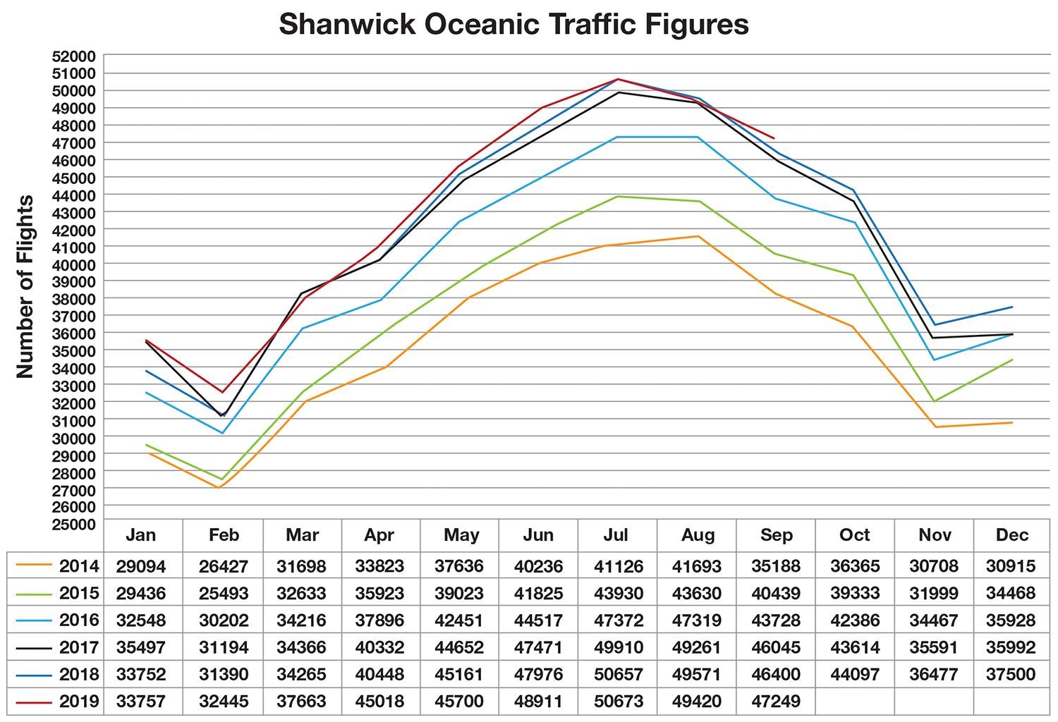
Any discussion about the value of satellite-based ADS-B always arrives at “efficiencies,” or how surveillance from 500 sm in space—an authentic “big picture” but in real time—can free operators from the limitations of procedural airspace control. “This means getting the desired flight level, flying at optimal speeds and having better access to the optimal track [of an Organized Track System],” Thoma explained. In a year in which there was substantial growth over the North Atlantic, one British Airways Boeing 787 made a transit in 3 hr. thanks to more efficient routing.
Then there is the safety issue—again enhanced by the perspective of the view from space, where ANSPs can see traffic coming before it enters their airspace, and automated features call operators’ and controllers’ attention to possible conflicts. “There’s a metric that the ANSPs in the North Atlantic apply to altitude busts, or large height deviations (LHDs) of 300 ft. or more,” Thoma said, “which are a persistent problem. Here, with Aireon, we see the value of the difference between real-time reporting of satellite-based ADS-B and the 10-min. reporting of ADS-C [Automatic Dependent Surveillance-Contract, the system recently mandated in North Atlantic airspace for procedural conformity].
“If Aireon ‘sees’ an LHD,” he continued, “it automatically sends a message to the pilot to check altitude. In other words, it sends an alert directly to the pilot—the alert no longer goes through the relevant supervisor’s desk and a subsequent radio call. This vastly reduces the time from the altitude bust to a correction. Now, for the first time, the Oceanic Control Centers [OCCs] can meet their target levels of safety.”
Out Over the North Atlantic
To get the perspective of that space-based view of oceanic airspace — a logical application for ADS-B because of the absence of radar surveillance — we talked with Doug Dillon, general manager of the Gander Area Control Center (ACC) operated by Nav Canada. “We had invested in ground-based ADS-B and were looking at opportunities for extending coverage in oceanic airspace to utilize surveillance to reduce separation as far east as we could,” he began.
At the time, separation in the North Atlantic was 10 min. in trail, a significant distance of up to 80 or 90 nm, depending on the longitude. “A radar cost $8 million to install,” Dillon said, “while a ground-based ADS-B station cost $800,000, so we went with the latter and began installing [ground stations] along the Canadian coast and in southern Greenland. This gave us the ability so see aircraft farther into oceanic airspace. Then in 2012, our CEO pitched the idea of space-based ADS-B with global coverage and what that could mean to our customers. So, we partnered with Aireon, a huge collaboration of systems, procedures, safety management and other benefits.”
If an air traffic management system could add more beneficial flight profiles earlier and faster, more efficient and safer operations would be possible because controllers would have “extrapolated targets” to work with. “Under procedural ops,” Dillon explained, “we had to apply longer separations because we couldn’t actually see aircraft”—in other words, “extrapolate” where they were.
One of the biggest areas of improvement with space-based ADS-B is “the safety aspect of being able to see targets going from end to end between North America and Europe,” Dillon said. “This would give us a significant improvement to our target level of safety. The other impact is service to the customer in terms of efficiencies: more efficient profiles, lowered separation allowing more aircraft to operate in a given area at a time.”
Normally, 85% of aircraft were getting their requested routings, flight levels and speeds (in the non-surveilled scenario), “but we weren’t meeting all three criteria—the routing is the easier one; the harder one in the non-surveilled environment would be the flight level. When we looked at space-based ADS-B, we went from a 10- to a 5-min. longitudinal separation, equating from 40 to 80 nm down to 14-17. Due to the reduction in separation standards, it increased a significant capacity to put aircraft at their most-optimal profiles. So, those were our two biggest gains: a safety bump and a significant increase in efficiencies.”
Beginning in 2015, the transition to space-based ADS-B was “a significant collaborative event” between Nav Canada and Britain’s NATS, as between them, the two ANSPs control about 85% of North Atlantic traffic. “So we knew that for a successful implementation,” Dillon continued, “it required us to be on the same page, a common technology platform, so controllers could be able to adequately position aircraft at the handoff points. We would have to incorporate the new separation standards as well as the collaboration tool built into the system for safety assurances.” The earlier controller system was called GAATS; when NATS joined the Nav Canada platform, new technology requirements were developed to launch GAATS+. All testing was collaborative, with procedures aligned under the International Civil Aviation Organization (ICAO) and the North Atlantic Systems Planning Group (NATSPG) regulatory umbrella. Altogether, the effort consumed three years of development and testing—and lots of transatlantic meetings.
Game Changer
“The first ADS-B launch went up in January 2017,” Dillon said. “As the satellites were becoming operational, we would receive data on them, and it was impressive the coverage we could get with one satellite—two-thirds of the oceanic airspace! We could see coverage from just one satellite and see twice what was originally predicted. It took a year to get the others in place, and we went live in our domestic [Canadian] airspace first on March 19, 2018, and on the 21st in our oceanic operations.
“As we went through the testing phase,” Dillon continued, “it was apparent how robust the system was. When we started with space-based over the ocean, we were getting metrics for the customer where we now had real-time surveillance of every equipped aircraft in the entire North Atlantic between Nav Canada and NATS. It is second to none in terms of our goals. Unfortunately, the pandemic has slowed us down in terms of gaining our full benefits, but nevertheless, it still provides significant safety benefits and reduction of separation. It has been a game-changer for oceanic airspace and is proving to be a solid system.”
And the safety payoff includes flight profiles that might be out of conformance in terms of lateral and vertical deviations with their operators’ clearances. “Our system knows the trajectory of every aircraft and its profile,” Dillon claimed, “and if the target deviates from that profile, it will immediately alert the controller that the aircraft is deviating in either the horizontal or vertical plane.” The ANSPs are also implementing a “deviation tool” that gives the controller the ability to protect aircraft in the case of weather deviations, based on the deviating pilot’s request. “In the procedural world, when pilots needed to deviate around buildups, often an ATC clearance would not be available,” Dillon said, “and the pilots would take contingency procedures for the deviation with the knowledge of traffic passed to them. With surveillance and the reduction of separation standards, we can now provide deviation clearances while having a system monitoring the aircraft’s profile.”
Thanks to these tools, gross navigation errors (GNEs) have almost become “a thing of the past” because oceanic controllers receive early warnings of deviations. “We can message to the avionics automatically so that, prior to entering oceanic airspace, the system can probe the avionics to ensure the recorded profile matches the profile protected by the ATC system,” Dillon said. This is in lieu of the old read-back by the crew and the possibility that the course might be entered incorrectly. Now, if there is an incorrect coordinate, the system can determine it and alert the pilot. (This is an ADS-C function that is also being implemented for space-based ADS-B.)
A Controller’s Perspective
At NATS’ Prestwick Center, development head Jim Nelmes recognized the long-running partnership with Nav Canada to devise a strategy for joint ways of managing the two ANSPs’ mutual oceanic airspace with more consistency.
“We’d agreed with them that this was something we wanted to develop, and we already had their software, so we were using the same systems as Gander,” he told BCA. Given the mutual use of the software, it was then an easy step to integrate the Aireon data into the NATS system.
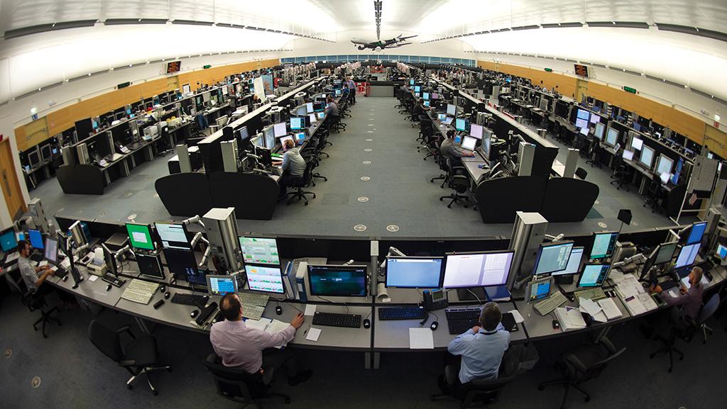
In the busy months before the pandemic, ops performance manager Jacob Young said, “We were receiving 130 million ADS-B reports into Shanwick, the busiest oceanic control center in the world.” (The Irish Aviation Authority’s Shannon Center and Prestwick Center jointly control the Shanwick Oceanic Control Area.)
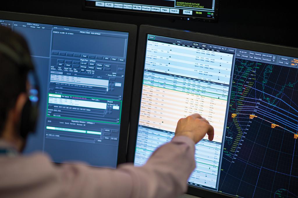
Rob Mitchell has been an oceanic operational controller at Prestwick for 14 years, enough time to live through the transition from “old school” procedural control to today’s Automatic Dependent Surveillance and Controller-Pilot Data Link Communication (CPDLC) systems. The former tells controllers where aircraft are—or confirms where they are supposed to be—while the latter facilitates textual communication in lieu of scratchy, interference-prone high frequency (HF) radio. Together, these technologies transform oceanic air traffic management from a level of assumption to one of knowledge.
“We were operating in an old-school environment in many ways,” Mitchell began, “a hands-off approach to control using procedural operations. It’s not quite real ATC, which for most controllers is a desire to actually run a radar sector. The GAATS system didn’t change on the opening day [of space-based ADS-B surveillance]—we still had our map displays, paper strips, and so forth—but the reality of the [existing] situation was guesswork on where we thought the aircraft were. And all of a sudden, we were not procedural airspace controllers anymore—now we could match the situation to where the aircraft actually were. A powerful moment! We now had that capability on our own sectors—doing things we could only imagine.” In other words, oceanic controllers could “see” the aircraft they were vested with controlling—and for which they were ensuring safety. Powerful, indeed.
In the past, controllers played catch-up, responding to messages from their aircraft or neighboring sectors. “But now we are getting the ability of seeing the aircraft before they enter our sectors,” Mitchell continued. “We have a service volume area that not only encompasses our airspace but 200 nm all around it, another safety feature allowing us to perform conformance checks on known aircraft plus those on the way in.” Not only that, but Shanwick can see domestic traffic in UK and Spanish airspace that abuts its sector. “There are a lot of aircraft transiting through there but not entering oceanic airspace,” Mitchell said. “We can see them, too, and in the event that any of them get too close to our airspace or enter it, we would get an alert.”
Another place where non-oceanic traffic could be seen with Aireon ADS-B was the area adjacent to the southeastern corner of the Shanwick OCA. Young explained: “Another benefit we have now is the ability of non-data-link aircraft [i.e., those not equipped with the now-mandated CPDLC avionics] to traverse the southeast corner of our airspace from Ireland to the Canaries, and had we not implemented the system, they would have flown around that airspace, and now they can fly through the airspace, plus we have added VHF comm on two specific routes that run along our boundary with Brest. This provides reduced separation with an option to enter our airspace. That corner is particularly busy on a daily basis.”
Now, because Shanwick controllers can see aircraft 200 nm before they enter their system, they have a valuable assist for their decision making. “With time restrictions, there are concerns,” Mitchell said, “and previously, we had to call the appropriate control system and get a radar check on when an aircraft would meet our boundary — now we can see it, and we have tools to make decisions on how to handle it.”
More Real-Time Info
There are two functional controllers in an oceanic control center: the planning controller responsible for clearing aircraft from domestic to oceanic airspace and the en route controller or oceanic controller having responsibility for where aircraft actually are in the relevant airspace.
“We are still a procedural control unit,” Mitchell pointed out, “but by planning aircraft into oceanic airspace safely, we can control more aircraft. What ADS-B has allowed us to do is to have more up-to-date information on what is going on—a contingency, a deviation, level busts, an aircraft routing to an incorrect position, and so forth. Very much in the past we were playing catch up in terms of what aircraft were doing, and now we can see them leaving oceanic to domestic airspace.
“We can act on incorrect flight levels—sometimes innocent and sometimes a precursor to what might happen. A lower flight level might indicate the aircraft is having a problem and we can move other aircraft out of the way. Often when an issue develops, there isn’t time for the aircraft to call in, as the crew is handling a problem—remember the mantra, ‘aviate, navigate, communicate, in that order.’ Now we get a notification immediately if there is a change in height. Now we can be a lot more proactive.”
In their training and annual recertification, controllers are taught “what an aircraft is supposed to do,” Mitchell said, “but we don’t always know when and how that were to happen. With ADS-B, I can see now how they are doing what they are supposed to do—a reassurance. I now have the knowledge of what the crews are up against and how they are handling it and I can be sympathetic to the users.”
While North Atlantic airspace is still procedural, controllers can now see it, thanks to space-based ADS-B. “There are clear benefits from the surveillance environment,” Mitchell claimed. “We can now react to things we could not see before—a huge safety benefit. And because of it, we can now reduce the separation standards. And again, because of the benefits of having ADS-B in our airspace, we have managed to keep the same amount of controllers and still increase capacity in the sectors. We have been able to absorb the rise in traffic with these tools.”
Another windfall from space-based ADS-B involves service benefits. “We can absorb the increase in traffic with lower separation standards,” Mitchell said. “We have the tools that can do a sweep and look ahead to, for example, allow a requested change in flight level. And the system can check to ensure a planned level change has actually happened. We can give you more if you ask for it. Predominantly, the comm is by CPDLC, but we are still using HF. Also, satcom is being used more—it is always a backup to CPDLC and HF.”
But, according to Young, the biggest service delivery benefit with oceanic ADS-B passed on to customers is separation reduction from 40 to 14 nm, packing more aircraft into the same volume of airspace. “Last year, we handled 508,000 flights in our airspace,” he said. “The way we look at our performance is how often an aircraft gets a request satisfied. Prior to Aireon, we were getting 62%, but after ADS-B was introduced, we got a 10% improvement in the first year, and what that improvement meant was that 8,000 fewer flights had an ATC-enforced level change, and 7,000 fewer aircraft were given an entry point change. The second number is crucial because what it means is that we were able to halve the number of flights receiving entry point changes, reducing the number of miles added onto those flights previously.”
A Different Use of ADS-B
At Eurocontrol in Brussels—the only Aireon customer not using the ADS-B service for surveillance—Christos Rekkas, head of surveillance and code, described Aireon as “a useful tool for many applications but especially for flow management.” To fully understand this, consider that the intergovernmental agency coordinates air traffic management among 41 Western European member states and two associates in North Africa and the Middle East. Flow control is its raison d’etre and air transportation at modern levels simply could not function across the Continent without it. (See “Eurocontrol and Business Aviation, Parts 1 and 2,” BCA, October 2019, and November 2019.)
Eurocontrol began harvesting Aireon’s ADS-B data in February of this year. The applications include:
- Flow management.
- Crisis management.
- Contingency management, e.g., in case other data sources are temporarily unavailable.
- Safety assessments.
- Environmental monitoring.
- Performance monitoring of all sorts.
- Airport-related applications.
- Research and development.
“We get the data from the space-based system and are using it as an additional input to our applications,” Rekkas said. For Air Traffic Flow Management (ATFM), Eurocontrol will use ADS-B data for flight trajectory prediction in order to better estimate when aircraft will arrive in its airspace; software is currently being integrated into the Eurocontrol Network Manager and will be fully operational in early 2021. “Space-based ADS-B will provide us with information we did not previously have from outside the European network that can improve the quality of our trajectory predictions,” he said. “With the space-based ADS-B service, we now have traffic data up to 6 hr. out from European airspace borders in support of our flow-management systems. This is extremely important.”
The data can be used in other ways, too. “For example,” Rekkas continued, “we get it for environmental monitoring to see how the aircraft are flying close to the airports for more efficient routing. And we can use it for safety monitoring. We use it for crisis cases such as the current COVID pandemic in order to monitor the traffic evolution and patterns in specific parts of the airspace like the Middle East. We are also using it as input for seeing how systems are performing —a quality monitoring tool, if you will. Every application has a different way of using the data.”
The data is delivered by Aireon in two ways. The first is live-streamed every minute for the agreed area. “This is suitable for ATFM,” Rekkas said. The second option is historical information from an Aireon database that arrives at a higher data rate (on the order of seconds), and supports a variety of other applications.
Does Eurocontrol share the Aireon data with its member states? “We cannot provide the space-based ADS-B data itself to the Eurocontrol member states,” Rekkas said. “But we can provide the processed information—the output of the applications using the data. But in practice, all our applications aim at performance benefits to the member states and other stakeholders.”
The key benefit is improved predictability. “We know better when the trajectories will appear in European airspace. The current level of traffic predictability at the boundary of European airspace is estimated to be significantly less than in the core area.” This is because the peripheral ANSPs did not have sufficiently accurate information outside their borders for the incoming traffic, so were relying on predictions based on flight plans, which are not as accurate as the surveillance information.
Reduced predictability results in sector capacities having to be set at conservative levels with capacity buffers in order to avoid over-delivery of traffic. This, in turn, results in underutilization and reduced capacity and efficiency. “Now they will know exactly when the aircraft will arrive, and this will improve predictability. We would consequently like to unlock the capacity buffers, and we expect that the Aireon data will allow us to do this. In summary, we try to push the periphery to align with the core area with respect to predictability levels.”
Satellite-Based ADS-B’s Future
So, what other tasks will space-based ADS-B be put to? “We just completed a release . . . for a capability to see aircraft on the surface —that is, in the airport environment,” Aireon CEO Thoma told BCA. “A major benefit of a satellite-based system is that everything is software-defined, meaning we can upgrade the software in the satellites. Thus, we have an ability to enhance the system.”
The next standard for ADS-B (DO260C) will include weather information coming off the aircraft. “One [software] change can go across the whole constellation,” Thoma noted. “We have been investing heavily in how to make the data available to additional applications, not just ATC surveillance—a capability in a cloud-based environment to host the data and provide tools for use in other applications. Flight Aware is already providing a service to airlines using our data. For Airbus and Passur, which have customers in the airport environment, we can provide a tool-set they can use to support those customers.”
Gander Center’s Dillon looks out 10 years when “adding the fourth dimension of time gives the users predictability for profiles allowing efficient use of departure and arrival times as well as more control over contingency fuel, as less can be carried. In other words, you can better cope with a predictable profile rather than having to plan for worst-case scenarios.”
Prestwick Center’s Young believes the ability afforded by ADS-B to satisfy service requests will allow future developments like reducing the number of OTS tracks and eventually get to eliminate the track structure altogether. “The difference in performance of aircraft on random routes and on the tracks is getting closer and closer,” he observed, “and the likelihood of getting the route you want in the random area is increasing due to ADS-B.” As a result, the benefits of the OTS are decreasing “because you can get what you want more often in the random area.”
Will space-based ADS-B replace ground-based ADS-B? “There are still areas where you need ADS-B on the ground,” Thoma said, such as “highly congested areas needing redundancy and clarity with multiple forms of surveillance including radar. On the positive side, we were quite surprised with the amount of coverage we could get from space—the payloads are very high performance. The system allows multiple coverage—at least three satellites can see the aircraft over 80% of the Earth, so at least 80% of aircraft can be seen by three satellites.”
However, since one satellite can see the whole U.S., it can pick up all the equipped aircraft, and that’s a lot of signals. So, in congested areas like New York, Chicago, Atlanta or Los Angeles, it becomes challenging to deliver the information on the targets to the degree necessary for separation. “In that case, it becomes a situational-awareness tool,” Thoma suggested. And conventional surveillance radar will continue to be used in busy terminal areas to sort out the traffic. (See “Whither Analog Navaids?” BCA, October 2020.)
“But you can also see everything, including general aviation aircraft with bottom-mounted antennas, and you can see that their performance is not as good, so it gives you a tool to measure avionics performance on board the aircraft. That information is reported to our customers by aircraft ID and tail number. Aviation is built on multiple layers of redundancy, and this is one more layer of surveillance.”
Will Aireon’s space-based ADS-B replace ADS-C in oceanic airspace? “Both have their merits,” Dillon at Gander maintained. “ADS-B allows for full-time monitoring, but ADS-C provides a frontal view of what the aircraft is going to do, a projection of where it’s going to be. So both have their place.
“Aireon is stable and reliable,” he concluded, “systems are behaving, acceptance has transitioned well, and it’s hard to give the full benefits now because it’s only been operational for a year and we have the COVID-19 pandemic that has reduced traffic.”