From The Archives: Detailed Contour Map Of The Lunar Surface

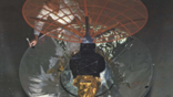
The cover of the Mar. 8 1965 issue of Aviation Week & Space Technology shows a detailed contour map of the lunar surface, developed by scientists at the U.S. Geological Survey's Flagstaff, Arizona, laboratories based on the last photograph made of the moon by Ranger 7.
The spacecraft was 1,000 ft. above the lunar surface, 0.176 sec. from impact when the photograph was taken. Dr. Eugene Shoemaker, chief of the survey's astrogeology branch, constructed the model using a specially designed photometric technique to produce three dimensions. Models of the Lunar Excursion Module and astronaut, are to scale.
Enjoy unlimited access to the complete Aviation Week Archive which has over 100 Years of Aviation Week — at your fingertips.
Every issue, every page, every article we have ever published. Your subscription includes full access to the archives, plus current Aviation Week & Space Technology articles (both digital and print packages available).
Related Content