Editor's Note: This is the first of two parts.
No one is immune to small lapses in concentration. Most of the time a brief lack of focus or awareness is harmless.
When the lapses involve radio communications at an uncontrolled airport, however, the results can be fatal.
Before two airplanes collided right in the middle of the Marion Municipal Airport in Marion, Indiana, each pilot had the opportunity to make a radio call at the right moment that would have prevented the accident, but neither one did.
Limits to visual lines of sight on the airport also partly obscured the pilots’ view of one another at critical moments.
The two airplanes were at opposite ends of the performance spectrum. One was a corporate jet, the other a small trainer. The pilots were at opposite ends of the experience spectrum, too. One had more than 35,000 hrs. of flight time, the other had only 71 hrs. But they were equals in the traffic pattern and had equal responsibilities to communicate.
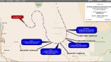
The date of the accident was April 2, 2018. On that afternoon, skies at Marion were clear but hazy. It was chilly, 5 deg. C (41 F), and the wind, 140 deg. at 9 kt, favored runway 15. Marion has two runways, 15 and 22, which intersect at midfield. The airport has a universal communications (UNICOM) frequency, 122.7, but no tower.
The jet aircraft, N511AC, was a Cessna 525C (Citation CJ4) on a business flight. It was inbound to Marion from the north after a full day of flying. The airplane had departed Marion at 0815 EDT with four employees aboard. It had stopped at Jackson, Michigan, Oakland/Troy airport near Detroit, and then Jackson again before heading back to Marion.
At 1706, the Citation pilot reported Marion airport in sight and was cleared for a straight-in visual approach to runway 22 by Grissom Approach Control. The pilot spotted an aircraft on his cockpit traffic display, but it was not the other accident airplane. At that point, the pilot canceled his IFR clearance.
Grissom Approach reported there was no traffic between the airplane and the field, and approved a change to the advisory frequency. It was 1707.
Just minutes earlier, the Cessna 150, N5614E, had begun to taxi from Marion’s ramp. After wending his way to the intersection of the two runways, he announced on UNICOM that he was back taxiing on runway 15. The Cessna 150 pilot made no further radio calls, but proceeded down to the end of the runway, turned around and began his takeoff.
At 1709, as the jet was rolling through the intersection of the two runways, the Cessna 150 struck the empennage of the jet.
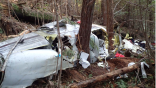
A witness said the Cessna 150 was about 10 ft. off the ground and pulled up steeply before striking the jet. Another witness said there was a “pop,” the airplane burst into flame and then became a fireball where it came to rest. Neither the pilot nor the passenger of the C-150 survived.
The pilot of the jet saw a flash out of the right side window and felt a yaw, but he said the airplane didn’t move much.
He brought the airplane to a stop, then turned around on the runway and taxied back to the runway intersection. He shut the engines down, opened the door and went to the other airplane.
Seeing one person, he checked him but found no signs of life. He then returned to his airplane and helped his passengers disembark. No one aboard the jet was injured. A passenger called 911 to report the accident.
The Investigation
The NTSB’s investigator in charge (IIC) was assisted by two FAA inspectors, an investigator from Cessna (Textron), the jet’s manufacturer, and an aerial imagery specialist. The imagery expert used a DJI Phantom 4 drone to survey the accident site.
The Cessna 150 was located on the grass next to runway 15. Due to extensive fire damage, the available evidence was limited. The left wing was crushed, the flight control cable continuity was established, and the seat belt buckles were latched. Investigators were unable to establish the elevator trim setting, the flaps position, the fuel selector position or the transponder setting or status. There was no evidence of any airframe or engine abnormalities prior to the collision.
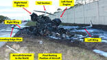
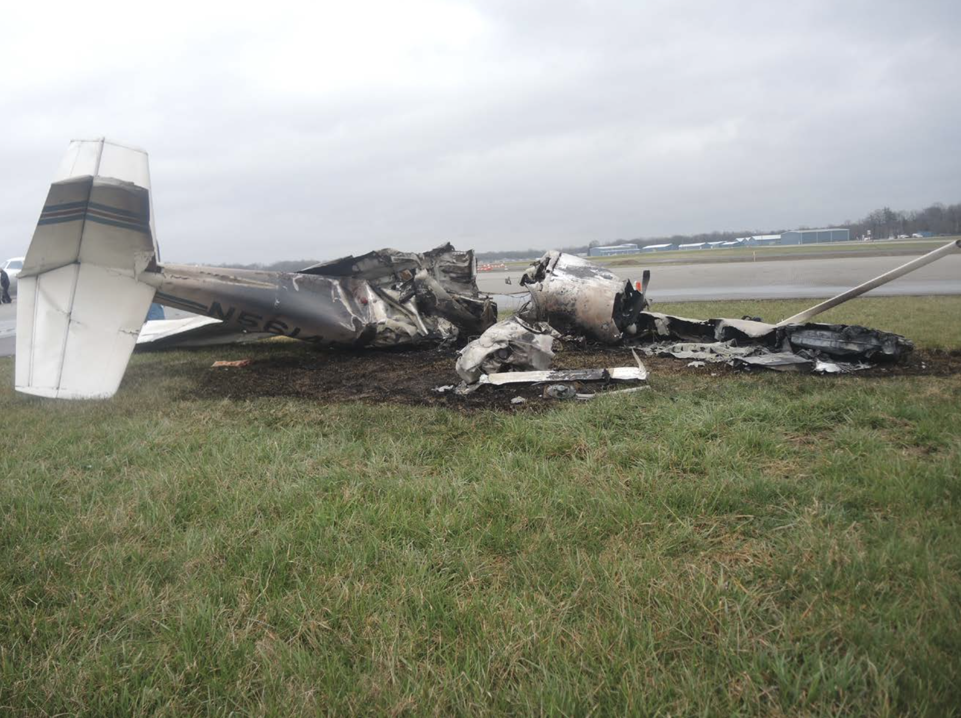
The jet’s tail section was in the grass near runway 22. The rudder and elevators were still attached to their respective stabilizers.
There was some damage to the right engine’s nacelle and to the leading edge of the vertical stabilizer, but the flight control cables remained connected. The cockpit controls and most of the airplane was intact. The airplane had not apparently experienced any malfunctions before the collision.
The aerial imagery specialist was able to photograph and map the airport area, including the infield, the runway intersection and the impact areas. In addition to documenting the wreckage, the drone photos were used to assess how well the pilots of the two airplanes could see one another just before the collision.
The specialist created an orthomosaic terrain map by flying a grid pattern over the airport, and took oblique photos of the VOR station located on the field and of the two aircraft. By flying the drone along the two runways, the specialist was able to approximate the viewpoint of the two pilots just prior to the collision.
Accuracy of locations and elevations on the airport was increased by use of a nearby GPS ground station and georeferencing software. The elevations were accurate to within 3.5 in. and positions to within 5.3 in.
Geographic data collected by the drone showed that there were points along runway 15 where the C-150 pilot would not have been able to see the landing jet at heights below 10 ft. because his view was blocked by the VOR station.
Marion Municipal Airport (KMZZ) is located 3 miles southwest of the town of Marion, Indiana. It is a public use airport and has been in existence since 1938. According to Airnav, there are 34 single-engine airplanes based there, along with two jets and two helicopters. General aviation constitutes 92% of the airport’s traffic and the airport is attended during daytime hours every day but Christmas.
The airport’s crossing runway configuration was popular in the tailwheel era, when crosswinds could be a more limiting factor to operations than today.
The airport’s terrain is basically flat, with the approach end of runway 22 about 8 ft. lower than the approach end of runway 15. Runway 22 has high-intensity runway edge lights and runway 15 has medium-intensity runway edge lights. The VOR on the field, frequency 108.6, forms part of airways V-11 and V-214 and provides a VOR approach to runway 15.
Airport officials were aware of the limited visibility by pilots on the two runways. All four runway ends had signs stating that traffic on the other runway cannot be seen and that pilots should monitor 122.7.
Please see the second of two parts of the Investigation and Conclusion in tomorrow's BCA Digest.

Related Content