There are many examples of experienced helicopter pilots flying into terrain. These cases often involve poor visibility and the pilot’s desire to complete his or her mission, whether it be mountain rescue, patient air ambulance or executive transport. When it happened near Raton, New Mexico, in 2018, the circumstances were familiar.
The Bell UH-1H “Huey” helicopter struck the ground 11 nm east of Raton at cruise speed. The aircraft was in level flight and in dark night conditions.
A first responder, who spoke to the pilot as he was being loaded into a rescue helicopter, quoted him as saying the accident was “all his fault” and that he flew into the terrain. The pilot died as a result of his injuries while en route to the hospital.
The pilot’s admission provided the answer to the question of what happened, and that was summarized by the NTSB. They found that “the probable cause(s) of this accident to be: The pilot's failure to maintain adequate altitude above mountainous terrain during cruise flight in dark night conditions, which resulted in controlled flight into terrain.”
This cause statement leaves open the bigger question of why it happened. We may not be able to say for sure, but supporting information in the accident report and further information about the interesting mix of people on board the helicopter point to some possible explanations.
The accident took place on Jan. 17, 2018. On that afternoon, a Hawker 800 private jet landed at Raton Municipal Airport (KRTN). On board were the owner of a newly acquired ranch near Raton and his guests. The jet had departed from Houston, the permanent residence of the passengers.
Waiting for them in Raton was the Huey helicopter, which was owned by Sapphire Aviation LLC. Sapphire was one of many companies owned by the new ranch owner. The Huey pilot was employed by Sapphire.
The purpose of the helicopter flight was to transport the five passengers to the Emery Gap Ranch, an 11,644-acre cattle ranch located about 35 mi. northeast of Raton and about 9 mi. north of the tiny hamlet of Folsom, New Mexico. The passengers were planning to celebrate a birthday at the ranch and return to Houston two days later.
After the passengers boarded the Huey, it lifted off at about 1750 Mountain Standard Time (MST) and proceeded in an east southeasterly direction. Although the skies were clear, night had fallen. Local civil twilight ended at 1735 and local moonset was at 1754. The one surviving passenger recalled seeing bright starlight, but in the absence of any ground lights or moonlight, the pilot would have been trying to see into what is commonly called a “black hole.”
The elevation of Raton Airport is 6,349 ft. MSL. After less than 10 min. of flight, the helicopter crashed at an elevation of 6,932 ft. MSL, only 583 ft. above Raton.
The surviving passenger, interviewed by an FAA inspector, said there was no turbulence during the flight and there were no warning lights in the cockpit. The pilot and copilot were calm before the passenger felt a “big bang” as they hit the ground. The helicopter rolled forward and came to a stop upside down. She found herself hanging in her seat by the seat belt and there was fuel pouring on her. She released her seat belt and left the aircraft. There were explosions and the helicopter was on fire. She called 911 and waited for emergency responders.
Because of the remote location of the accident site, no rescuers arrived for about 2 hr. Paramedics arrived at 2015. There were five fatalities.
The Investigation
The NTSB investigator in charge was joined by FAA inspectors and representatives from Honeywell Aerospace, Rotorcraft Development Corp. and the Air Accident Investigation Board (AAIB) of the U.K. An aerial imagery specialist from the NTSB also traveled to the accident site.
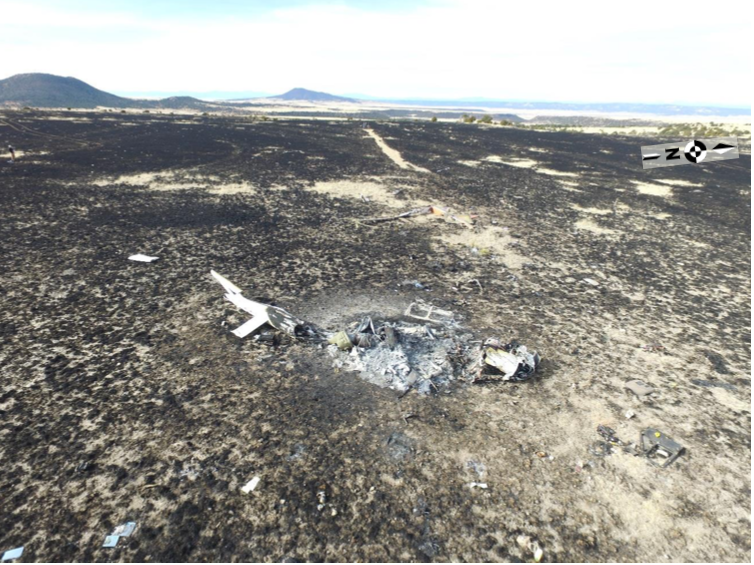
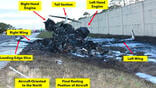
The wreckage was located on Blosser Mesa, about 2.5 m. southwest of Green Mountain. The terrain, which a casual observer might describe as flat, was actually a gradual upslope.
There was a 474-ft. ground scar formed by the helicopter’s skids, followed by the signature of the rotor blade striking the ground. The main rotor was found 60 ft. beyond the rotor strike and the remains of the cabin were found 66 ft. beyond the main rotor. The cabin was destroyed by fire. The grasses in the rocky area around the wreckage burned as well.
Investigators conducted a thorough examination of the wreckage. Cockpit instruments were charred and deformed, but two altimeters were found. Only the left-side instrument could be read, and it showed an altitude of 6,760 ft. The barometric pressure setting on the two instruments differed--one was 30.18 and the other was 30.28.
The weather at Raton at the time of the accident was wind direction, 030 deg. at 10 kt.; 10 mi. visibility; temperature, 1C; and altimeter setting, 30.26. There was no moon visible.
The front range of the Rocky Mountains meets the great plains at Raton. The area east of Raton is high table land punctuated by outcrops of volcanic rock and cinder cones. The plains are broken by eroded canyons that cut through sandstone layers. To fly directly from Raton to Emery Gap Ranch, you must cross a long finger of higher elevation land that runs southeast from 9,627-ft. Fishers Peak near Trinidad, Colorado, to Capulin Volcano National Monument in New Mexico, a cinder cone that rises to 8,182 ft.
The sectional chart for the area shows numerous peaks above 8,000 ft. and a minimum safe sector altitude of 9,200 ft. Contour lines on the sectional chart show few, if any, elevations where the helicopter could have crossed at an altitude below 8,000 ft. The Victor airway that most closely approximates the direct route of flight, V-263, has a minimum en route altitude (MEA) of 11,600 ft.
A ranch employee said the pilot most commonly flew there from Perry Stokes Airport near Trinidad and probably had not flown from Raton to the ranch before. The terrain between Trinidad and the ranch is depicted on the sectional chart as relatively flat, gradually sloping downhill to the east with typical elevations of about 6,500 ft.
The accident report does not speculate as to why the pilot was headed east southeast rather than northeast directly toward the ranch. It seems he may have been planning to intercept U.S. Highway 87 and follow it to the town of Capulin before heading north toward Folsom and the ranch. The sectional chart shows the highway generally lies between 6,500 ft. and 7,000 ft. The elevation at Capulin is 6,844 ft. Taking this southerly route could have appealed to the pilot if he wanted to stay low and navigate by using ground references.
The UH-1H helicopter, N658H, was originally manufactured in 1967 but was recertified in 2007 by Rotorcraft Development Corp. After being released by the General Services Administration in 1996, it was owned and operated by seven different operators before it was acquired by Sapphire Aviation on Feb. 10, 2017. It was certified as a restricted category external load aircraft, not for passenger-carrying operations.
According to maintenance records, in 2016, when the helicopter had 4,334.2 total hours, it was extensively modified. Among the many modifications were new flight, navigation and engine instruments. These included Garmin G500H PFD/MFDs, air data computers (ADC) and attitude heading reference systems (AHARS) on both the pilot and copilot panels, and a Garmin GTN 750H and a GTN 650H GPS display. In addition, a Garmin GTX 345R transponder and a GRA 55 radar altimeter were installed.
At the time of the accident, the helicopter had 4,420.5 hr. airframe total time.
In the second part of this feature, we’ll continue our discussion of the accident investigation.

Related Content


Comments