It’s hard to understand why a pilot chooses to take a risk he has been warned against taking. It’s even harder to understand when that pilot is a chief pilot, charged with training and checking other pilots and with supporting the safety practices of a company safety management program.
On Jan. 26, 2020, an experienced helicopter chief pilot with a celebrity client was handling a complex low-altitude flight skillfully until, over a very short period of time, he decided to take an unacceptable risk. While traveling at 140 kt., under a low overcast, and only 350 ft. above rising terrain, he decided to pull up into the overcast while operating under visual flight rules. Up to that point, he had several safe and reasonable options to deal with decreasing visibility. After that, his options narrowed. He became disoriented and the helicopter rolled over and impacted terrain 1 min. after he made that pull-up decision.
The accident took place in a hilly area in Calabasas, California. Calabasas is located at the west end of the San Fernando Valley, just 24 mi. from the flight’s destination. The flight departed from John Wayne Airport (KSNA), southeast of Los Angeles, and was bound for Camarillo Airport, California (KCMA), which is northwest of the city. The driving distance between the two airports along Interstate 5 and U.S. 101 is 92 mi.
On the day of the accident, the famous LA marine cloud layer covered the western part of the metropolitan area, making an IFR clearance the obvious plan of choice. Unfortunately, Island Express Helicopters, the FAR Part 135 operator of the flight, was not certified by the FAA to conduct IFR operations. The only VFR option was to stay low, below the cloud ceiling, which averaged about 1,000 feet AGL.
Los Angeles sits in a basin bounded along its north side by the San Gabriel Mountains, which rise to a height of 10,064 ft., and along its northwest side by the Santa Monica Mountains, which rise as high as 3,114 ft. To fly under a 1,000-ft. ceiling from KSNA to KCMA, a pilot must fly below the LA Class B airspace, past downtown LA, through the Elysian Valley along Interstate 5, through or around the Burbank Class C and the Van Nuys Class D airspace, and then through another pass at the west end of the San Fernando Valley. For a single pilot hand-flying a helicopter at high speed, the route was a tough obstacle course that would challenge the skills of even the best pilots.
The Flight
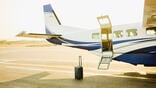
The Sikorsky S-76B helicopter, N72EX, departed KSNA at 0907. On board were the pilot and eight passengers, including former professional basketball player Kobe Bryant and his 13-year-old daughter. The flight was a repeat of a charter flight flown the previous day with the same pilot and passengers, and to the same destination. According to news reports, the purpose of the flight was for the passengers to attend a basketball tournament in which Bryant’s daughter was playing. Mr. Bryant was comfortable with the pilot, having flown with him many times before.
Before leaving, the pilot filled out a fight risk assessment form, a check box scoring system designed to help the pilot determine if conditions were too risky to fly. He calculated the flight’s risk at 17 out of 60 possible points, a very low score.
The helicopter skimmed along over the vast urban area following Interstate 5 North at altitudes above the ground of between 400 and 600 ft. and at speeds between 140 and 150 kt. Approaching the Los Angeles Zoo and just southeast of Burbank Airport (KBUR) Class C airspace, the pilot called KBUR tower and requested a Special VFR (SVFR) clearance through their airspace, specifically asking to follow the 101 Freeway westbound. SVFR rules allow a helicopter to be cleared through an area of controlled airspace when the visibility is less than the normal VFR minimum of 3 sm. However, it does not give the SVFR aircraft precedence over other aircraft that are operating under IFR, and there was IFR traffic operating at Burbank.
The helicopter began circling over Glendale while waiting for further clearance. Notably, the pilot asked the tower controller for a tops report while he was holding, and the KBUR tower stated cloud tops were 2,400 ft. MSL. After an 11-min. delay, KBUR tower cleared the flight to take a northwesterly course through his airspace rather than the requested westbound course due to traffic at Van Nuys Airport (KVNY). According to the KBUR and KVNY controllers, this northerly loop was a routine route, and apparently the pilot agreed, because when cleared that way, he said “no problem.”
Ten minutes later he had completed the semicircle around the valley and spotted the U.S. 101 freeway again, which when followed would take him to Camarillo. The pilot switched frequencies to Southern California TRACON (called SOCAL on the radio) and reported he was in VFR conditions and proceeding to KCMA. The controller told him he would lose radio and radar contact soon if the flight remained so low, and instructed him to change his squawk to 1200, the standard VFR code.
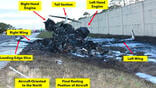
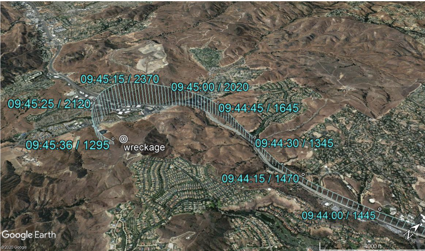
Within another 2 min. the helicopter began to encounter thicker clouds. A witness later said she saw the helicopter flying at or just below the cloud line and then disappear into a “thick wall” of cloud. At that moment, the pilot was telling SOCAL that he was “gonna go ahead and start our climb to go above the, uh, layers, and, uh, we can stay with you here.” He began climbing up into the cloud deck at 1,500 fpm and in a slight left bank.
The sequence of events during the next minute provides a textbook example of what happens during spatial disorientation. While in a rapid climb and gradual left bank, the pilot carried on several routine-sounding transmissions with the controller, each time causing him to think about something other than controlling the helicopter. Within a 30-sec. period, the pilot had to state his position, push the transponder “ident” button, answer if he wanted flight following, and reply to a request to “state intentions.” While this was happening, the helicopter was passing the highest point in its climb, rolling more to the left and beginning to descend. The pilot’s answer to that last request was the clincher. “Climbing to 4,000,” he said as the helicopter was now descending. The time of impact was just after 0945:34.
Ironically, if the last tops report was accurate, the helicopter got within 30 ft. of breaking out on top of the cloud deck before descending into the ground.
Editor's Note: This is the first part of a three-part series.

Related Content