John Werth of the Seattle ARTCC Weather Service Unit alerts pilots that there is no perfect ground or airborne method for detecting hazardous weather. Cockpit weather radar systems are not inherently better than NEXRAD or any other ATC weather detection systems. They are just different, each with their advantages and disadvantages.
According to Airbus’ Adverse Weather Operations, Optimum Use of the Weather Radar, a weather radar system is only helpful if the flight crew is able to fully use its capabilities and properly interpret the screen display.
Each type of weather radar has its own particularities and does not display a given weather situation in the same way as another type of weather radar. It is therefore necessary to study the manufacturer’s user guide in order to gain a good knowledge of your system’s capabilities and limitations.
Previous generations of aircraft weather radars use parabolic antennae and C-band frequencies (4,000 to 8,000 MHz). Newer weather radars are fitted with flat antennae and use X-band (8,000 to 12,500 MHz) frequencies that offer the following advantages: higher pulse energy; a narrower beam that significantly improves target resolution; higher reflectivity and, therefore, a higher total energy return; turbulence and windshear detection; and low power consumption. This new technology has higher attenuation and, therefore, a decreased ability to determine if there are weather cells with high levels of precipitation.
Radar returns depend upon the size, composition and number of precipitation droplets. Water particles are five times more reflective than ice particles of the same size. Radar is effective at detecting rainfall and wet hail. Heavy droplets (thunderstorm droplets) will return the majority of the energy in radar waves. According to Honeywell’s Weather Radar Systems User’s Manual with Radar Operating Guidelines, large, wet hail creates the strongest reflectivity of any kind of precipitation particle. However, rain can also give rise to high radar reflectivities. The difficulty in using radar reflectivities is knowing how to attribute the signal to different types of particles.
Weather radar, if not correctly used or interpreted, may mislead the flight crew when dry hail precipitation returns a relatively weak echo. Dry hail (a hail pellet that is totally frozen without a thin layer of water on the surface) is a very poor reflector of energy and can lead to an underestimation of a storm’s intensity. Upper levels of a towering cumulonimbus may contain ice and, therefore, may return radar images that do not represent the severity of its activity. This is problematic for turbine aircraft cruising at high altitudes far above the freezing level where the super-cold temperatures are more likely to produce dry hail.
According to Werth, attenuation can also occur when heavy rain or ice builds up on the radome, when the radome is damaged, or when it isn’t maintained.
The shape of radar echoes, as well as their color, should be observed carefully in order to identify storms containing hail. Closely spaced areas of different colors usually indicate highly turbulent zones. Some shapes are good indicators of severe hail. Fast-changing shapes, whatever form they take, also indicate high weather activity.
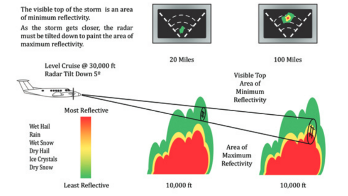
Antenna tilt should be adapted to the nav display range selection. In most cases in flight, the adequate antenna tilt setting shows some ground returns at the top edge of the nav display. However, at takeoff or in climb, the tilt should be set up if adverse weather is expected above the aircraft. The antenna tilt should be changed periodically when changing altitude unless the weather radar is fitted with an auto-tilt function in order to avoid over-scanning or under-scanning.
In order to get better weather detection, weather radar antennae should be pointed toward lower levels where water can still be found. If a red area is found at a lower level, the antenna tilt should be reduced to scan the area vertically. Presence of yellow or green areas at high altitudes above a red cell are indicative of a very turbulent area.
An indication of “light” precipitation at high altitude might be rain that is evaporating, or being held up by strong updrafts and possibly being frozen into hail. If the area of light precipitation seems to be at a high altitude and moving in front of the direction in which the storm is moving, it could be an anvil with hail.
To avoid a large storm, the flight crew must make decisions while still 40 nm away from it. Airbus recommends that the pilot monitoring select a nav display range (typically 160 nm and below) to assist with long-term weather avoidance course changes, and the pilot flying select 80 nm or below to tactically avoid adverse weather.
The weather radar system should not be used as a tool to penetrate or navigate around areas that are displayed as severe. It should only be considered as a tool to be used for weather avoidance.
Editor's note: This is the third part of a three-part article. Oh Hail and Understanding Hail were the first two.

Related Content