Researchers in the field of atmospheric science use sophisticated models and terminology to discuss the hail accretion (i.e., growth) process. The scientific papers use terms such as “convective available potential energy” to discuss the growth of tiny hail embryos through a cloud’s liquid water accumulation zone. It is a meteorological measure of how much energy an air parcel would gain by being raised to a specific height in the atmosphere.
Hailstones are formed when raindrops are carried upward by thunderstorm updrafts into extremely cold areas of the atmosphere and then freeze. They grow by colliding with liquid water drops that freeze onto the hailstone’s surface. If the water freezes instantaneously when colliding with the hailstone, cloudy ice will form as air bubbles that will be trapped in the newly formed ice. This is the process associated with “dry” hail stones. It tends to occur if the air temperature is well below freezing. If the water freezes slowly, which occurs in portions of a cloud where the air temperature is below freezing but not super cold, the air bubbles can escape and the new ice will be clear. The hail falls when the thunderstorm's updraft can no longer support the weight of the hailstone, which can occur if the stone becomes large enough or the updraft weakens.
Hail strikes are a worldwide hazard. Hail is most common in mid-latitudes during spring and early summer where surface temperatures are warm enough to promote the instability associated with strong thunderstorms, but the upper atmosphere is still cool enough to support ice. Hail has a strong diurnal character with the peak in observations occurring in the late afternoon.
Paradoxically, there is less risk of hail in humid air than in dry air. Why? Moisture in the air behaves as a heat conductor, helping to melt the hail. Hail at the surface is less common in the tropics despite a much higher frequency of thunderstorms than in the mid-latitudes. This is because the atmosphere tends to be warmer to greater depths over the tropics. However, hail does occur regularly throughout the year in the tropics and does create a threat to aviation at altitude.
Hail is more common along and near mountain ranges due to orographic lifting, which intensifies the updrafts within thunderstorms. Samuel J. Childs, a doctoral candidate in Colorado State University’s Department of Atmospheric Science, has studied the severe hail climatology in Eastern Colorado. The Front Range and Eastern Plains of Colorado experience some of the most frequent and intense hailstorms in the U.S. The metropolitan Denver area sees anywhere from 11 to 13 severe hailstorms each year. The area’s location in the immediate lee of the Rocky Mountains, as well as the interface of a cold continental air mass from the north and a warm and moist air mass originating from the Gulf of Mexico, make it a favored location for all forms of severe weather. Other unique topographical features across Eastern Colorado, such as the Palmer Divide and Cheyenne Ridge, provide additional sources of lift, which promotes severe hailstorms.
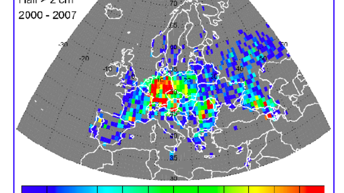
A similar trend is noticeable in Europe. Mapping of the frequency of hail over Europe from 2000 to 2007 shows a marked increase near the Pyrenees and the Alps, and a rapid decrease in frequency north of 60 deg. north latitude.

A team of atmospheric science researchers at Colorado State University led by Dr. Kristen Rasmussen has studied the deep convective storms over South America, which are known to produce frequent large hail. Hail in this region has been known to cause extensive damage to property and agriculture (e.g., wineries, soybean and wheat crops) due to its large size and frequency, especially in central Argentina near the Andes foothills. These storms frequently form near complex terrain and often grow upscale in place, producing deep hail accumulations in addition to the large hailstones.
Forecasting Hail
Hail prediction is subject to the largest uncertainties of all precipitation, according to atmospheric scientist Julian Brimelow, Ph.D., of the Meteorological Service of Canada. Brimelow outlined many of the causes of uncertainty during his keynote address titled “Bridging Knowledge Gaps in Hailstorm and Hail Research” at the First North American Workshop on Hail and Hailstorms (Aug. 14-16, 2018, Boulder, Colorado). The growth of hail, and especially large hail, requires the alignment of several key ingredients, and the final size of hail is determined by myriad processes occurring across a wide range of storm dimensions and time.
Weather forecasters look at key features of large convective storms in hopes of providing precious advance warning of severe weather. Multi-cell storms contain cells at different stages in the life cycle. The updraft drives the production of cloud droplets and ice particles. This leads to the production of graupel (soft hail or snow pellets) and the onset of strong radar echoes in the upper parts of the cloud.
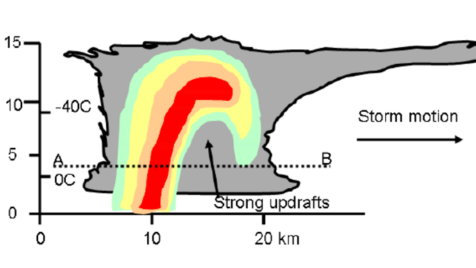
A “supercell” can have long-lived updrafts and downdrafts existing adjacently that drive the generation of large precipitation particles without destroying the updraft. Such systems are characterized by regions of strong slanting updrafts producing supercooled droplets. The falling (and evaporating) precipitation will generate a downdraft that can reinforce the updraft at the front of the system. This can produce long-lived storms.

"Hail is an increasingly costly problem, but hail research in North America has largely languished since the 1980s," said National Center for Atmospheric Research (NCAR) senior scientist Andrew Heymsfield, Ph.D., a co-chair of the hail workshop. "Improving predictions and better protecting society will require a greater emphasis on hail research, including advanced radar measurements and developing an aircraft with the capability of flying into hailstorms to take detailed measurements."
The National Severe Storm Laboratory (NSSL) is one of the centers of excellence trying to improve hail forecasting. It was a pioneer in dual-polarization radar technology, now installed on NWS radars across the U.S., to clearly identify rain, hail, snow or ice pellets. Dual-polarimetric radar transmits and receives pulses in both a horizontal and vertical orientation. The returning frequencies provide measurements of the horizontal and vertical dimensions of the storm. This gives forecasters more confidence to accurately assess weather events because they will have more information to predict what kind of precipitation there will be and how much to expect.
NSSL scientists are developing algorithms that will produce estimates of whether the precipitation is falling in liquid or frozen form, or if the precipitation is reaching the ground. The NSSL Field Observing Facilities and Support (FOFS) group has built a special balloon-borne instrument called a Particle Imager, designed to capture high-definition images of water and ice particles as it is launched into, and rises up through, a thunderstorm. The instrument is flown as part of a “train” of other instruments connected one after another to a balloon. These other instruments measure electrical field strength and direction, and other important atmospheric variables such as temperature, dew point, pressure and winds.
Avoidance Recommendations
Avoiding a hail encounter requires proper usage of the aircraft’s weather radar as well as following current guidelines for avoiding dangerous convective cells by sufficient distances. Simply skirting the areas of intense thunderstorm activity may not be enough to avoid the weather. High vertical expansion clouds are representative of high-energy air movements. Pilots should plan a weather deviation path early, and en route deviations should be made upwind of the storm when possible, especially if winds aloft are strong. Early collaboration with ATC on a re-route is more likely to result in a lower workload and staying farther away from threatening weather. Wise flight crews try to avoid a situation in which they are making constant requests to deviate.
Deviating downwind greatly increases the chance of encountering hail and turbulence as hail falls from the anvil or is tossed out the side of a storm. “Stay visual and stay dry” is a good goal. Avoid flight under the anvil. Hail has been encountered as much as 20-nm downwind from large thunderstorms.
When deviating around thunderstorms at higher altitudes, pilots should avoid the "blow off" that may produce significant turbulence. Avoid cirrus and cirrostratus layers downwind from the storm tops. Such layers may be formed by cumulonimbus tops and may contain “dry” hail, even though the radar shows little or no return echoes.
Editor's note: This is the second part of a three-part series. The first focuses on flying through hail.


