Much can be learned about the ferocity of hail encounters from those unfortunate enough to have been in the front seat as hail pounded the windshield. The good news is that FAR Part 25 certified aircraft are designed to withstand encounters with this severe weather, and thus flight crews have been able to land them, sometimes under emergency conditions, with no loss of life. Unfortunately, however, the airframes often needed extensive repair.
This author read through 740 pages of NASA Aviation Safety Reporting System (ASRS) reports involving hail encounters, searching for a handful of useful hints that could help pilots. The reports were submitted not only by pilots but also by mechanics and air traffic controllers who have critical roles in the air transportation system.
The standard recommendations in our industry to avoid hail damage focus on proper interpretation of the weather radar as well as keeping a sufficient distance from threatening weather cells. In the majority of the ASRS reports, the flight crews exhibited every intent of following those recommendations, but they still encountered severe weather that threatened the safety of their passengers and the structure of their aircraft. The reports contained lengthy narratives explaining the “how” and “why” of these encounters with violent weather. There is much to be learned from these experiences so that the rest of us don’t end up calling the boss to explain why the leading edges of the jet are wrinkled like tin foil and require extensive repairs.
‘Others Are Reporting Only Mild Turbulence’
Many of the ASRS reports indicated “Other aircraft were getting through the weather experiencing just mild turbulence and rain,” or that their airborne radar was only indicating light to moderate rain.
“If I had a do-over, I would have trusted my gut. As we approached our destination, I mentioned to the first officer that I didn't really like the radar picture and maybe we should just hold out to the west and wait for the storms to subside or move off. Approach Control was busy with multiple aircraft and trying to get everyone sequenced for the approach. He told us that others in front of us had experienced moderate to heavy rains with good rides. His assurances became the carrot held out in front.” Like many of us in a nearly identical situation, this flight crew accepted vectors for the approach, but their luck ran out with a hail encounter that resulted in aircraft damage.
Thunderstorms are dynamic. They can grow at impressive rates, and our industry has painfully learned from accidents caused by microbursts that the onset of extreme weather can occur with little warning. An important lesson from these ASRS reports is to avoid being tricked into thinking that your penetration will be similarly uneventful when others have reported “mild” conditions.
‘It Didn’t Look Bad’
There is a common perception that hail is produced by towering cumulonimbus clouds that stretch up to the stratosphere. Thus, flight crews have been unpleasantly surprised to encounter hail from cells that appear small on the aircraft’s radar.
“We were already deviating off the route for small cells as depicted on the radar…. We entered the clouds at approximately FL190. Descending through approximately FL150 we entered an area of moderate/severe hail for about 10 sec…. Considering our avoidance efforts, the shape and tops of the clouds, and what was being painted on the radar, I still remain stunned that hail to that severity was in the vicinity of the weather we were maneuvering around. When I suggest all reasonable efforts were taken to avoid the severe weather, I mean it sincerely.”
Other flight crews misinterpreted the lack of radar returns to indicate the lack of severe weather ahead or misinterpreted the returns for heavy rain.
‘Thought We Could Outclimb the Cloud’
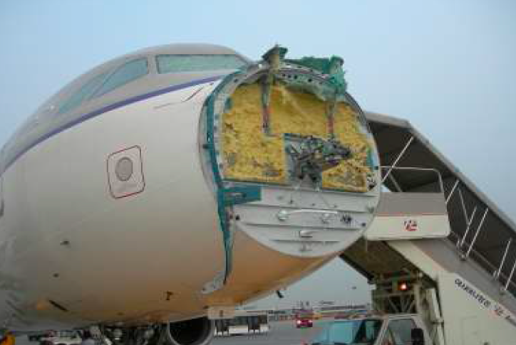
The flight crew of an Airbus A319 was cruising at FL370, initially estimating that they could overfly a line of thunderstorms. However, as the Airbus got closer to the weather it appeared that the aircraft would not be able to stay in VMC above the storm. The flight crew asked for a climb to FL390 but were denied. They initially experienced only moderate turbulence and what they thought was rain. The conditions then degraded to severe turbulence with hail. The airspeed fluctuated +/-30 kt. and the altitude varied +300 to -700 ft. The aircraft exceeded its high buffet airspeed limitation for a short time. While in IMC the weather radar became inoperative. Once the aircraft exited the cell into clear weather the flight crew noticed an unusual wind noise and suspected damage to the nose cone. Upon landing at their destination, the aircraft was grounded.
It might be tempting to think that one’s jet can out-climb a growing thunderstorm. There are several reasons why this can turn into a regrettable condition. First, the updrafts in thunderstorms can easily exceed the climb rate of jets. A specially modified T-28 operated by the South Dakota School of Mines and Technology for inflight research of deep convective storms recorded updrafts in excess of 3,900 fpm. Let’s put this into a real-world situation. Put yourself 40 nm from a storm, roughly 6 min. away from a cell that appears lower than your aircraft. In those 6 min. the storm cell could blossom an additional 23,400 ft. higher in altitude.
Researchers at the National Center for Atmospheric Research (NCAR) have discovered that updrafts within intense thunderstorms may penetrate several thousand feet into the stratosphere before they are overcome by the atmospheric stability. The strongest updrafts can often be identified visually by cumuliform bulges that extend above the otherwise smooth anvil top of the thunderstorm. NCAR’s Dr. Bruce Carmichael emphasizes that this convective-induced turbulence (CIT) can extend quite high over the top of a storm and cannot be detected by radar.
Inadvertent encounters with CIT create a threefold threat to an aircraft in high-altitude flight. First, the air is warmer than the surrounding air, which creates an immediate decrease in thrust. Second, the aircraft is suddenly at a higher density altitude where the buffet margins are thinner. Third, modest turbulence of 1.4 G (which is an increase of only 0.4 G over straight-and-level) can reduce an aircraft’s margin over the buffet to no protection.
Not Understanding the Limitations of NEXRAD
John Werth of the Seattle ARTCC Center Weather Service Unit informs pilots that there is no perfect ground or airborne method for detecting hazardous weather. Cockpit weather radar systems are not inherently better than NEXRAD or any other ATC weather detection systems. They are just different, each with their advantages and disadvantages.
NEXRAD radars emit beams at several different angles to completely map the sky. The image from the lowest beam is called base reflectivity. Base reflectivity shows the precipitation that is falling from the bottom of a cloud. However, it does not show what is falling at higher flight levels. Composite reflectivity combines the strongest return from all angles into a single image.
ARTCCs utilize NEXRAD data that is fed through the weather and radar processor (WARP). This process organizes the 16 NEXRAD levels into four reflectivity (dBZ) categories. Reflectivity returns of less than 30 dBZ are classified as “light" and are filtered out of the center controller's display. The remaining three categories correlate to bands of dBZ values to assist pilots in evaluating the severity of flight conditions that might be associated with those precipitation returns.
According to the FAA’s Weather Radar Echo Terms, approach control facilities do not utilize NEXRAD or WARP. Instead, radar weather echoes are displayed by the airport surveillance radar (ASR) systems using digital processors paired with a weather processor to display the four weather radar echo intensity categories to the controller. The scan rate for ASR is 5 sec., which provides a nearly instantaneous update of changes in radar signal returns from precipitation.
Some aircraft are using data-linked weather information, which includes displays of NEXRAD images. The most important aspect that a pilot must understand about NEXRAD is that the mosaic image takes time to collect and assemble. The image is assembled from multiple radar ground sites. The NTSB Safety Alert “In-Cockpit NEXRAD Mosaic Imagery” (revised December 2015) warns pilots that when a mosaic image is updated, it may not contain next information from each ground site. The age indicator on the mosaic image on the cockpit display does not show the age of the actual weather conditions. Instead, it displays the age of the mosaic image created by the service provider. Thus, the image will always be older than the age indicated on the display.
The NTSB’s Safety Alert notes that the delays in processes used to detect and assemble the NEXRAD data from a ground site to a service provider, as well as the additional time needed for the mosaic-creation process, can result in the oldest NEXRAD data exceeding the age indication in the cockpit by 15 to 20 min.! This becomes especially problematic in weather that is dynamic (i.e., thunderstorms) and/or fast-moving aircraft. NEXRAD data lags behind, therefore, not showing the exact location of precipitation. The in-cockpit NEXRAD display depicts where the weather was, not where it is.
NEXRAD does offer distinct advantages over airborne weather radar. It is not as prone to attenuation as aircraft radar due to its utilization of signals from multiple radar sites. NEXRAD’s useful range is between 143 and 286 mi. depending on the surveillance mode, and thus it detects weather at much greater distances.
In Part 2, we’ll discuss how hail encounters often produce a multitude of failure messages in the cockpit.

Related Content