"Bring your patience with you” is the advice offered by savvy travelers. Eventually, you will get to your destination after enduring various slow, burdensome processes. That advice may also be helpful to airline executives watching developments in Europe’s air traffic management.
- Free-route airspace gains ground
- Operator puts numbers on satellite-based approach benefits
The glass is arguably half empty, if that glass is the 1990s commitments to a harmonized airspace under the Single European Sky (SES) concept. But it is steadily filling. A number of projects being implemented simultaneously mark progress in air traffic management (ATM) efficiency for air operators. And they are evidence of a solid trend in modernization and streamlining.
Lobbying groups such as the International Air Transport Association, Airlines for Europe and the European Business Aviation Association regularly complain about slow progress, if any, in the SES project. They express concern that improvements that could reduce aviation’s environmental footprint, cut ATM costs and minimize delays are being held up.
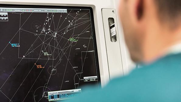
Optimizing an aircraft’s trajectory over a continent is complicated when ATM is structurally fragmented.
DSNA, France’s air navigation service provider (ANSP), is renewing its ATM hardware and software. The 4-Flight system, six years late in deployment, is intended to improve interoperability with neighboring countries’ systems. “Interoperable” also means different, highlighting the missed opportunity of using a single system across Europe.
En route control centers, where controllers watch over aircraft in their cruise phase, are still defined by borders. A notable exception is the Maastricht Upper Area Control Center (MUAC) in the Netherlands. MUAC manages the upper airspace, from 24,500-66,000 ft., over Belgium, the Netherlands, Luxembourg and northwest Germany—one of Europe’s busiest and most complex airspace areas. It is the only cross-border civil-military ANSP in Europe. It describes itself as building services around traffic flows, not national borders.
That scheme has proved successful. Eurocontrol is MUAC’s parent organization and in charge of ATM in Europe (including Turkey and the UK). It has long clamored for an extension of the principle of basing an airspace’s limits on flows.
So-called functional airspace blocks (FAB) were an attempt along those lines in the mid-2000s. The EU’s airspace was divided into nine large FABs. They proved only partially effective, however, partly due to member states’ reluctance.
MUAC and German ANSP DFS have found a different—and possibly more effective—arrangement.
They have introduced the first package of their large-spectrum airspace optimization plan—the Cooperative Optimization of Boundaries, Routes and Airspace (COBRA). Three design changes for the airspaces controlled by MUAC, the Karlsruhe Upper Area Control Center and the Langen Area Control Center have been operational since October. Under the COBRA design, airlines can plan shorter routes, such as through the TRA Lauter military area when it is inactive.
The boundaries between MUAC and Karlsruhe UAC airspaces have been adjusted to improve routes and flight profiles and simplify procedures.
Even more ambitious, free-route airspace (FRA) is an organizational change that is rapidly advancing. Under the concept, flight crews choose their preferred routes in a relaxed framework. Spanish ANSP Enaire, which began implementing FRA in April, explains that flight crews may plan to fly between two points even if they are not connected by an airway. A crew is allowed to map out the optimal route in terms of distance flown, wind and weather.
With FRA, carriers can expect more direct routing, resulting in time and fuel savings. Controllers anticipate better trajectory predictability.
The flexibility enabled by FRA seemed impossible in the past. But technology has moved forward and cross-border collaboration has intensified, progressively overcoming national interests. FRA is gradually becoming the norm in Europe.
FRA implementation in Europe started in 2015 in Hungary. A significant milestone was reached when, in November 2019, a large cross-border FRA was created over Bulgaria, Hungary, Romania and Slovakia.
Two years later, two major ANSPs, the UK’s NATS and DSNA, started FRA operations over large parts of their territories. In the UK, NATS implemented the largest geographical airspace change in the country, removing long-established air routes over Scotland. In France, DSNA has put FRA into action in nearly 50% of its airspace. The altitude above which the evolution is effective is 25,000 ft. and 19,500 ft., respectively, which in both instances ensures most of the cruise phase takes place in the relaxed framework. As a result, NATS expects CO2 emissions equivalent to 3,500 homes’ are being saved, at 12,000 metric tons per year.
When FRA is fully implemented across in Europe, 10,000 metric tons of CO2 will be saved per day, Eurocontrol predicts. This works out to about 2% of commercial air transport’s emissions in Europe, which will contribute to a forecast 10% of CO2 emission reductions just from improvements in ATM and operations by 2050.
In the UK, FRA currently represents one-third of total airspace. It is the first of four proposed deployments introducing FRA there. In France, DSNA has implemented FRA in three en route control centers out of five.
“We are working on extending the use of FRA into more complex airspace and with lower vertical limits,” says Eurocontrol Director General Eamonn Brennan.
He advocates for first adequately introducing any new principle before widening its application. The first step is often the most difficult: finding pioneers. In France, Air Corsica’s new Required Navigation Performance-Authorization Required (RNP-AR) approval may end up convincing others that time, money and effort put into satellite-based approaches is worthwhile. The carrier expects its schedule at Ajaccio Napoleon Bonaparte Airport to become more reliable in winter, when weather conditions turn unfavorable. In addition, ecological benefits from the approach phase may accrue year-round, both in CO2 emissions and noise.
The transition to satellite-based approaches has been frustratingly protracted, and carriers have often criticized ANSPs for that slowness. Conversely, carriers have been slow to adopt new systems such as satellite-based navigation equipment for precision approaches.
Air Corsica’s management team sees the recently obtained go-ahead as the beginning of a story. “In 10 years from now, RNP and RNP-AR approaches will be a standard for challenging runways,” says Herve Pierret, a member of Air Corsica’s management board. RNP-AR approaches are even more precise than RNPs and can include curved segments.
Corsica is a French mountainous island and its home carrier has a particularly strong case for RNP-AR.
The procedure could avoid 10 diversions per winter at Ajaccio, Pierret estimates. A typical diversion means an Airbus A320neo flies a waiting pattern for 40 min. before the crew gives up due to a persistent tailwind on the runway, an unfavorable condition for landing. The aircraft would then fly to Bastia, on the north end of the island. There, buses to Ajaccio would need to be arranged for up to 186 passengers. At best, the 150-km (93-mi.) drive is 2.5 hr. long.
Choosing the required equipment as an option on an A320neo only costs a few dozen thousand dollars, Pierret says.
The RNP-AR procedure provides enough accuracy to use the preferred runway direction at night or in poor visibility. “You fly close to the mountains but the satellite guides you and the autopilot does the job until the runway is in sight,” says Pierret.
Moreover, the new approach is more direct. The procedure makes the flight 4 min. shorter and cuts CO2 emissions accordingly. Even better, the approach no longer overflies the city of Ajaccio, reducing the number of local residents who can hear the aircraft.
Air Corsica is the second carrier to be approved by France for the approach (Air Austral has been using it at Saint-Denis Airport on the Indian Ocean island of Reunion, a French department). But it is the first to offer cogent details, which DSNA hopes will convince other operators in the country.
The 44 European Civil Aviation Conference (ECAC) states have over 6,000 separate ground-based facilities dedicated to communications, navigation and surveillance, Brennan notes. “That represents an annual infrastructure cost of around €1.3 billion [$1.4 billion],” he says. “With a more coordinated approach and a better use of satellite-based technologies, this cost can be reduced.” Many ECAC states are already reducing the number of facilities, such as nondirectional (NDB) and very-high-frequency omnidirectional-range (VOR) beacons, he adds.
Satellite-based approaches use the European Geostationary Navigation Overlay Service (EGNOS), Europe’s regional satellite-based augmentation system. EGNOS V3 is in development, and its initial service performance has been successfully reviewed, says system provider Airbus. EGNOS V3 uses both Galileo and GPS signals—the current EGNOS version only uses GPS—and will feature several advancements. For instance, monitoring ionosphere-induced position errors will be improved, resulting in better service availability in the western and southwestern periphery of Europe.

Related Content