This article is published in Aviation Week & Space Technology and is free to read until Jul 26, 2024. If you want to read more articles from this publication, please click the link to subscribe.

GPS Interference Grows As A Concern For Civil Aviation

GPS spoofing heat map

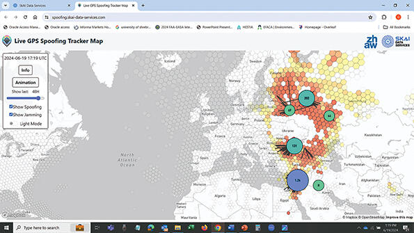
SkAI Data Services’ live tracker shows the concentration of GPS jamming and spoofing around Ukraine and Syria.

Credit: SkAI Data Services

Increased jamming and spoofing of GPS have regulators and startups alike looking for ways to detect and mitigate the impact on civil aviation of interference with global navigation satellite signals, unintentionally and intentionally.

Most of the interference has been seen in Eastern Europe and the Middle East, where jamming and spoofing of GPS is being used as a defense against drones in conflicts in Ukraine and Syria. But jamming has also been seen in the U.S.

  • Jamming can be discerned from ADS-B data
  • Spoofing is more dangerous but also harder to detect

Jamming—the unintentional or intentional denial of signals—is relatively simple to detect using data already included in automatic dependent surveillance-broadcast (ADS-B) messages transmitted by aircraft. But spoofing is harder to combat—and potentially more dangerous—as it involves the malicious manipulation of signals to mislead the GPS receiver about its actual location.

While jamming has been a recognized problem since the early days of GPS due to the satellite signals’ very low power, spoofing is a relatively new and growing issue for civil aviation. This is because the techniques are increasingly being used in combination to combat the massive growth in the use of drones in conflicts, making signals unreliable over large areas around war zones.

Globally, the average number of GPS signal-loss events was 24 per 1,000 flights before May 2023, when interference began to peak, says the International Air Transport Association (IATA). Events spiked by almost 79% to peak in August 2023 at 40 events per 1,000 flights before dropping to 34 per 1,000 flights. The current average number of events is still 40% higher than the baseline, the organization says.

According to IATA, Europe accounted for almost 70% of GPS signal-loss incidents from January 2023 to March 2024, the Middle East and North Africa 15.4%, the Commonwealth of Independent States 7.2% and the Asia-Pacific region 3.6%. The U.S saw less than 1% of events.


In the U.S., where jamming remains the principal issue for civil aviation, Mitre Corp. has developed a prototype system called the Navigation Operational and Planning Agility Suite (NOPAS) for the FAA to monitor signal degradation and assess its impact on aircraft navigation.

The federally funded research and development center points to two recent cases in the U.S., at Denver International Airport in January 2022 and Dallas-Fort Worth (DFW) International Airport in October 2022. The event at Denver lasted 33 hr. and affected aircraft within a 230-nm radius at altitudes up to 36,000 ft. The interference was traced to a source unintentionally emitting a signal on the GPS L1 frequency. The DFW event lasted 24 hr., and the source of interference was never identified, ending on its own.

“When GPS signals become unavailable, the FAA needs to know as quickly as possible,” says Wayne Cooper, NOPAS project lead at Mitre. “They also need to know whether ground-based navigation aids are available for use in the affected region so they can determine the best means to maintain safe and efficient flight.” Mitre is working to accelerate the speed at which NOPAS processes data. “Right now, we can identify a GPS degradation event within a few hours of when it began,” Cooper says. “Our target is to do it within 15 min.”

The U.S. jamming events in 2022 underlined the importance of backup navigational aids. “No quantifiable effect of the GPS disruption could be observed at either airport, despite the closure of a runway at DFW,” states a June 14 report by policy consultancy London Economics International. “The readily available backup systems at DFW and [Denver] and the aircraft’s immediate ability to revert to these systems preserved value and prevented disruption.”

The same was not true at Tartu Airport in Estonia, where Finnair suspended its flights on April 29 this year after GPS interference forced two of its aircraft to abort landings there. Unlike Denver and DFW, Tartu had no ground-based navigation aids. The airport subsequently installed non-GPS backups, and Finnair resumed flights on June 2.

Today, air traffic controllers typically find out about GPS degradation events through pilot reports. But ADS-B messages from aircraft contain data about GPS accuracy and integrity. NOPAS uses this data to identify jamming events in near real time, Mitre says. The system produces a heat-map display of the locations where GPS is unreliable, overlaid with a map showing the other navigation systems pilots can use in these regions.

“Today, the impact of a GPS jamming event can last for several days,” Cooper says. “By reacting faster, the FAA has the potential to limit the impact to a few hours.” Disruption can also result from planned GPS jamming in support of U.S. military exercises. As a result, additional NOPAS capabilities are being developed to help the FAA better coordinate with the Defense Department on scheduling.

As a next step, Mitre plans to develop the capability to distinguish GPS jamming from spoofing. But detecting spoofing is more challenging and requires more data than just that from ADS-B. “There will be several methods, including comparing radar data to ADS-B data and looking for system dynamics that aren’t possible for the aircraft, such as derived aircraft velocities that aren’t physically possible,” Mitre says, adding that it “is also pursuing onboard spoofing detection algorithms.”

While Mitre says spoofing is “very, very rare” in the U.S., it is not so in Europe and the Middle East, says Benoit Figuet, co-founder of SkAI Data Services. The Swiss startup provides an open-access, live GPS interference tracker using ADS-B data provided by OpenSky Network. And spoofing is on the increase. “There has been jamming around Syria for years. Now we see spoofing on top,” Figuet notes.

Detecting GPS spoofing with just ADS-B is impossible, Figuet says, although it is possible with wide-area multilateration, a surveillance system that uses a network of ground sensors to cover an area in combination with ADS-B. “Post-processing is easier than live, as you can check for jumps in aircraft position,” he says. “But it doesn’t really work as you catch all the noise in the data.

“We assume it is not targeted spoofing, so we look for concentrations of aircraft,” Figuet continues. “We can detect it if more than one aircraft is spoofed. We usually have jamming at the same time in the same area. With jamming, we lose position, but still get accuracy data [from ADS-B], so the aircraft disappears, appears at the spoofed location, then reappears.”

There are also distinct patterns to spoofed flights. “Some airplanes are spoofed to a static location, some of them are circling, and some of them are doing weird shapes,” he says. Recently, SkAI detected spoofing of flights between North and South Korea. Although only four spoofed flights were detected by the live tracker, post-processing revealed more than 40 flights were affected on May 28-30.

“The GPS spoofing we’ve observed in Korea is something new . . . and quite different from what we see elsewhere,” Figuet says. “Unlike the constant positions, circular patterns or ‘&’-shaped patterns we see in Crimea, the spoofed locations in Korea were changing frequently.”

Spoofed GPS signals can affect not only aircraft position information, but also ground speed and altitude indications as well as the aircraft’s clocks, says the U.S.-based National Business Aviation Association. The erroneous position information may also set off the aircraft’s terrain alerting systems in all flight phases and lead to other confusing aircraft behaviors.

Spoofing can also lead to issues hours later, Figuet notes. The reason why this happens is not clear but could be related to how the flight management system processes data, “and we believe it could be different between aircraft types,” he says. 

Graham Warwick

Graham leads Aviation Week's coverage of technology, focusing on engineering and technology across the aerospace industry, with a special focus on identifying technologies of strategic importance to aviation, aerospace and defense.

Comments

1 Comment
The State of Colorado implemented wide area multilateration (WAM) in the mountains of Colorado in 2013 to provide surveillance for 8 ski country airports. The northern constellation was WAM only, while the southern has dual string WAM ADS-B. the idea for the southern constellation was to provide a backup to ADS-B and also have the ability to verify ADS-B data.