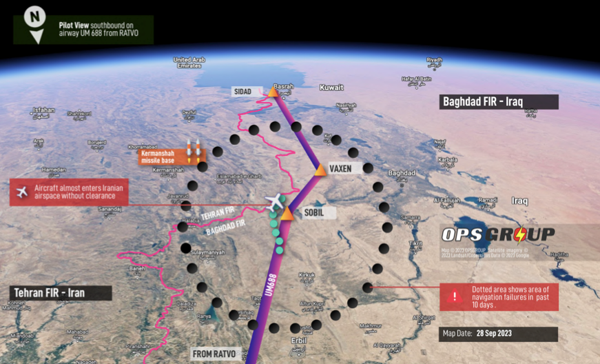
Aircraft afflicted with GPS Spoofing have flown perilously close to the Iranian border without clearance to fly into Iran's airspace.
A serious threat to the safety of air navigation has emerged in recent weeks, occurring to a wide range of civilian transport aircraft while traversing airspace in which deviations would lead to intrusions into Iranian airspace without a clearance. The culprit appears to be fake GPS signals which are causing complete navigation failure.
OpsGroup, a membership organization specializing in international flight operations, has collected 20 separate incident reports as of September 28, 2023. The number of incidents and the geographic focus of these recent incidents make this more than a mere coincidence.
Nefarious (though yet to be identified) forces are likely behind this, and the consequences could turn into an international crisis and possibly the loss of an innocent civilian aircraft in a region that is already a high-risk area near an active conflict zone.
The name of this new menace is “GPS Spoofing”, which is different from GPS jamming. GPS jamming means that one’s aircraft is unable to receive standard GPS signals and the aircraft’s navigation system must rely on other inputs to determine its position. Aircraft equipped with advanced Inertia Reference Systems (“IRS”) are able to continue operating sufficiently when GPS signals are jammed, but GPS Spoofing is a new threat which found a hidden back-door through the navigation software to completely disable the entire navigation system.
The Flight Management System (FMS) uses a hierarchy for its navigational information, beginning with GPS, then in subsequent order it uses the IRS, DME/DME, VOR/DME, and finally Dead Reckoning modes. An IRS uses a combination of gyroscopes, accelerometers and electronics to provide precise attitude, trajectory and navigation information. One advantage of inertia navigation is that it can work in all environments. However, inertia navigation “drift” errors accumulate of time, and if they are not updated at sufficient intervals with correct positional data, this can lead to large position errors. When GPS signals are not available, such as during GPS jamming, the sensor fusion software utilizes the other sources of information to provide precise navigation continuously.
These latest incidents involve “Spoofing” in which the false GPS signals trick the aircraft’s FMS into indicating that the aircraft is more than 60 nm off-track, and then completely disables the aircraft’s Inertia Reference System (IRS). Since the IRS utilizes GPS signals to continuously update the position information, the navigation system software assumes that the fake GPS is correct, causing the IRS to fail. When the navigation system compares the (fake) GPS signals to other navigation inputs such as from ground-based nav-aids, the software is unable to comprehend the gross error, and all of the navigation systems end up being corrupted.
These recent incidents are indicative of an active attack on an aircraft’s total navigation system. Furthermore, current IRS systems were not designed to counter this type of attack. All of the reported “GPS Spoofing” events experienced an unusable IRS and, in many cases, all navigation capability was lost.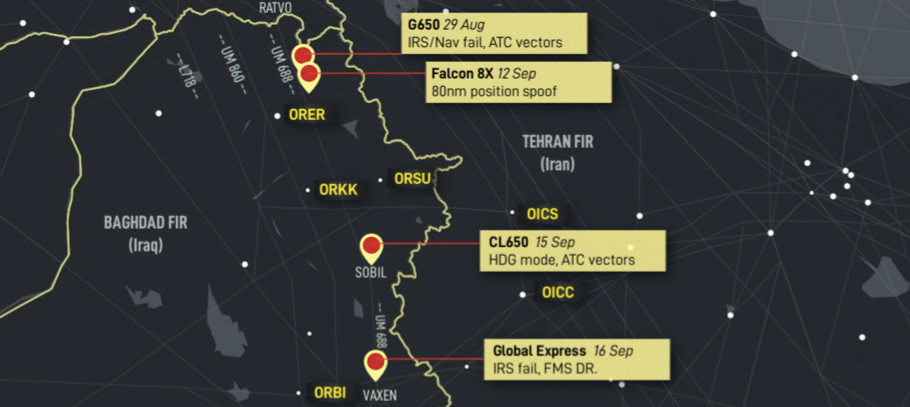 Credit: OpsGroup
One of the reports in the OpsGroup database occurred on Sept. 9 to a Challenger 604 while on a flight from Europe to Qatar. The route of flight went through Turkey and Iraq. The aircraft experienced minor jamming while transitioning from Bulgarian to Turkish airspace. As they neared the Turkey/Iraq border, they lost both GPS sensors but continued the flight with the back-up navigational input in the IRS. North of Baghdad, the flight crew lost anything related to the navigation system, and the IRS indicated that they had drifted 70-90 miles off track. Furthermore, the avionics indicated a ground speed of zero and 250 knots of wind. The FMS’s reverted to the dead reckoning mode, but with no accurate update of their position, the flight crew had no reliable navigation information. At this point, the flight crew relied on ATC vectors to their destination.
On Sept. 15, an Embraer Legacy 650 operating on Airway UM688 experienced a similar set of failures and nearly entered Iran airspace with no clearance. Other aircraft involved in similar incidents include the Challenger CL650, Dassault Falcon 8X and Bombardier Global Express.
Has Your Aircraft Been Targeted?
Clues that your aircraft has been targeted by spoofing include a large Estimated Position Uncertainty (“EPU”), incorrect display of the UTC, a large shift in the GPS position, nav page or PFD warnings about position error, as well as other aircraft transmitting comparable errors.
There is potential for this type of event to be seen elsewhere. While the reports in recent weeks are concentrated near the Iranian border, the risk of inadvertently flying through another sovereign nation’s airspace without permission has resulted in severe reaction in the past. Civilian transports have no defensive capability against sophisticated surface-to-air missile system.
This was evidenced on Aug. 29, 1999, when Eritrean air traffic control (ATC) reported loss of contact with a Learjet 35A while en route from Luxor, Egypt, to Nairobi, Kenya. Ethiopia had posted a warning that flights directly from Eritrea over Ethiopia were prohibited. The flight plan was filed through Djibouti to avoid an Eritrean/Ethiopian border crossing. The airplane was later found crashed near Adwa, Ethiopia. The Ethiopian Defense Force reported a shoot-down of an aircraft in the vicinity. Both pilots were fatally injured, and the airplane was destroyed. There were no passengers.
If the sneak signals are entering through the infected GPS signal, is it possible to erect a “firewall” from allowing these to get into the IRS? Hopefully. Since this is a rapidly emerging new threat, much work must now be done to detect how these menacing signals are able to sneak through the software. This will likely require a multi-layered solution to include a software fix from the manufacturers to find the sneak circuit and erect the equivalent of a firewall.
Recommended Actions
In the meantime, are there any recommendations on what flight crews can do in flight if the aircraft appears to be the victim of spoofing? Mark Zee of OpsGroup recommended de-selecting the GPS on the sensor page. This will cause the NAV system to revert to signals from the DME/DME and VOR/DME modes if nearby navaids are available. Alternatively, the NAV will degrade to a dead reckoning mode. This latter step is completely dependent upon the navigation unit having an accurate last update on location. Zee also recommends using conventional ground base navaids (VOR/DME/NDB).
Zee pointed out that FBW aircraft have extensively integrated GPS into their designs to such an extent that the FAA has issued warnings to these aircraft to avoid areas where GPS spoofing or jamming may be active.
Manufacturers of military navigation systems have been developing a multi-layered approach to combat the problem of GPS disruptions. For instance, Honeywell has introduced a multitude of alternative navigation systems to augment the availability, integrity and performance of inertia navigation. They have developed a Vision Aided Navigation System using a live camera (optical and/or IR) which compares the image with maps to provide an un-jammable position with a horizontal position accuracy of 10 meters. Their Celestial Aided Navigation system utilizes a star tracker. It is likewise un-jammable and recently demonstrated an accuracy of 30 m. An Embraer 170 was recently used as a test platform to demonstrate the effectiveness of Honeywell’s Magnetic Anomaly Aided system which measures the earth’s magnetic strength to compare with magnetic maps to identify a vehicle’s position. Honeywell’s Radar Aided system uses radars to measure velocity and provide this information to the INS, thus improving the INS’s accuracy.
While some of the avionics manufacturers already have this in-house expertise to provide military aircraft with alternative navigation in GPS-denied environments, will these methods be readily adapted for civilian use? Perhaps not due to their complexity and expense, however, their in-house expertise likely has already done extensive studies trying to solve this problem for the military. The knowledge learned from those studies may be useful solving this new threat in the civilian sector.
Clearly the avionics manufacturers will be scrambling their sneak circuit specialists to find out how these nefarious GPS signals are entering into the navigation system, and then fix these holes.
This problem will also require specific air crew training to help them detect these errors, understand the error messages on the FMS, PFD and ND, as well as being informed on recommendations to resolve these in-flight, especially for flight crews transiting high-risk flight regions. Many of us will be standing by for official guidance from authoritative sources on this emerging threat.

Related Content