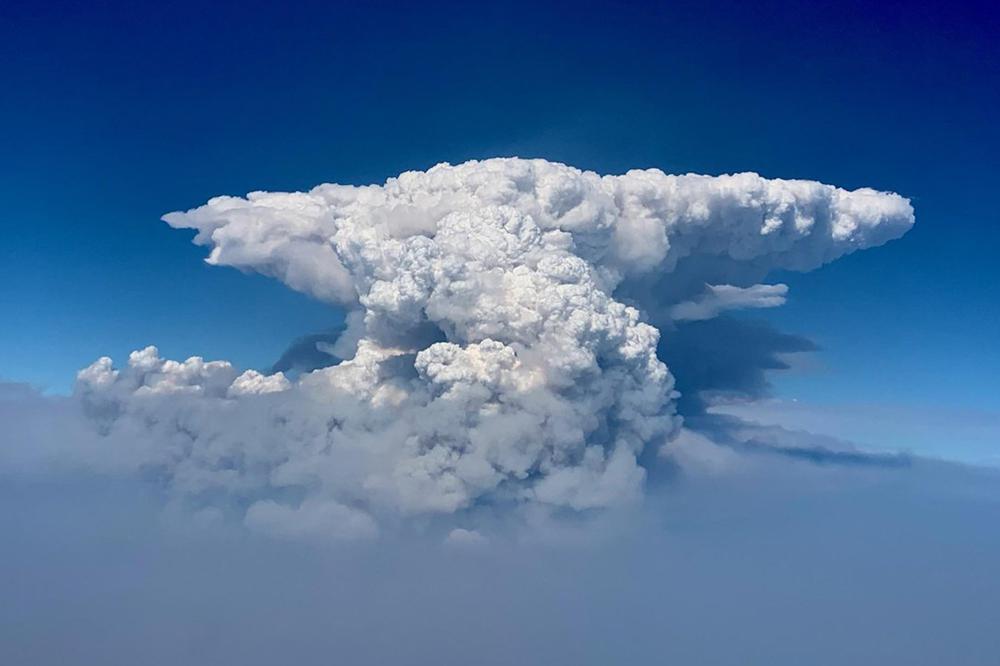
In recent weeks we have witnessed historically-sized wildfires that created their own weather and frequent lightning from a newly designated type of towering cloud called “pyrocumulus,” or recently abbreviated to simply “pryoCBs.” “Pyro” derives from Latin for “fire” and CB as the common abbreviation for cumulonimbus.
The threats from pyroCBs are considerable. According to the U.S. National Weather Service office in Boise, Idaho, the Bootleg Fire in south-central Oregon produced a pyroCB event almost every evening for several days in a row. By no means are these threats limited to just the western U.S. A pryoCB event not long ago in Portugal cost 60 lives, illustrating the power of this atmospheric phenomenon as well as its international applications.
The emergency preparedness community is desperately seeking to understand and predict this powerful atmospheric phenomenon to help better prepare for evacuation and mitigation. The immediate concern for public safety focuses on the wildland fire management teams who work along the fire lines directly adjacent to this billowing monster.
An aerial fire fighting captain who has flown countless sorties along the edges of the Bootleg Fire queried, “Hey doc, we’re listening to these briefings from the incident command weather teams about these pyroCBs. The effects on the fire front are jaw dropping. What are the effects on the aviation side?” This avid BCA reader also happens to be an airline pilot in the off-season, thus his query carried considerable concern that would potentially apply throughout many aviation sectors.
At this reader’s suggestion, I reviewed the scientific research to date on pyroCBs. The research summarized in this article opens definite questions about the effects of pyroCBs on aircraft.
What Is A PyroCB?
On July 21, the U.S. Naval Research Laboratory (NRL) conducted an online press conference about pyroCB. It included Dr. Mike Fromm, a scientist at the U.S. NRL in Washington, DC., who tracks pyroCB storms using satellite imagery, and Dr. David Peterson, a meteorologist with the Monterey office of the NRL, who specializes in earth and atmospheric sciences.
According to these two respected researchers, pyroCBs are fire-induced thunderclouds that inject massive amounts of smoke particles into the upper atmosphere. It begins as a typical wildfire reaches its daily crescendo in the late afternoon. It is the hottest part of the day with the lowest relative humidity, atmospheric instability and probably accompanied by erratic winds. These are conditions conducive to significant fire growth. When these events are hot enough, wildfires can trigger convective updrafts, the depths of which extend well into the lower stratosphere.
Even though the recent news is focusing on pyroCBs coming from wildfires in the western U.S., wildfires in Canada and Australian have spawned tremendous pyroCB events with global implications, and in recent weeks we are seeing pyroCBs in other places across the globe.
How Does It Form?
According to Dr. Peterson, “These are thunderstorms driven directly by large wildfires. The smoke plume is fed directly into the developing cloud on top of the fire. Think of them as chimneys funneling smoke released by fire up into a thunderstorm, and then ejecting it at whatever altitude the thunderstorm tops out at.”
A research report written by a team of atmospheric scientists led by Dr. Peterson and published in the scientific journal Climate and Atmospheric Science provided contrasts and comparisons with typical convective storms. “PyroCbs are characterized by relatively smaller cloud droplet and ice particle size distributions, caused by an overabundance of smoke particles. What will this mean for the flight crew at high altitude? These particles typically provide a low radar signature.”
“Smaller inherent size distributions within the inner storm core suppress precipitation, which inhibits scavenging and redistribution of smoke downward toward the ground. A considerable quantity of smoke particle mass is therefore exhausted from the top of pyroCbs through the high-altitude anvil outflow region, forming an efficient vertical smoke-transport pathway. PyroCB activity is often characterized by extreme updraft velocities (up to 6,900 fpm to 11,400 fpm!) that rapidly transport smoke particles directly from the surface to the lower stratosphere, similar to an explosive volcanic eruption.” (source: Peterson David A., et al. “Australia’s Black Summer pyrocumulonimbus super outbreak reveals potential for increasingly extreme stratospheric smoke events,” Climate and Atmospheric Science, 13 July 2021.)
According to Peterson’s observations, “It is an extremely dirty thunderstorm with a lot of smoke particles for water to condense on.” That creates differences in the properties of the cloud. It isn’t every efficient at generating precipitation. The droplets don’t get large enough to fall as rain. But it is a cloud that can produce a lot of lightning.
By the way, I double checked the references on the updraft velocities in these clouds. Consider the significance of an updraft that can project a particle from the ground to above 30,000 ft. in just 3 minutes! From an aviation perspective, that is an airmass with strength far beyond the capability of any aircraft. Secondly, whenever there are rapid inflows of wind of this magnitude into a thunderstorm, there will be severe downdrafts. The atmospheric specialists on the incident command teams briefing the fire fighting squad leaders are warning that the downdrafts, usually downwind, can produce erratic winds at the surface. This would be a risk to ground-borne fire fighters as well as the aerial fire fighting aircraft in the vicinity of this enormous cloud.
Editor's Note: Subsequent parts of this article on pryoCBS will examine flying near these clouds and the impact on aircraft systems.

Related Content


Comments