This article is published in Aviation Week & Space Technology and is free to read until Jan 09, 2026. If you want to read more articles from this publication, please click the link to subscribe.

GPS Needs To Toughen Up, Or Get Trampled Down

GPS Blk. III space vehicle

A GPS Blk. III space vehicle.

Credit: U.S. Air Force

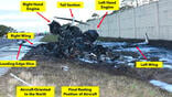
GPS is under siege from hostile forces. In 2024, there were as many as 700 daily GPS jamming and spoofing incidents, according to an analysis of ADS-B reports by Switzerland’s Zurich University of Applied Sciences (ZHAW). The Swiss institution recorded 41,000 GPS spoofing events from Aug. 15 to Sept. 15 last year.

One of the deadliest GPS L1 civil signal interference events occurred on Dec. 25. On that date, Azerbaijan Airlines Flight 8243, an Embraer 190, was lured off course while enroute from Baku, Azerbaijan, to Grozny, Russia. When it strayed, Russia fired a surface-to-air missile at the airliner. The exploding warhead riddled the aircraft’s hydraulic system with shrapnel, crippling the jet.

The pilots struggled to maintain control of the doomed airliner, but were forced to crash-land at Aktau, Kazakhstan, resulting in the deaths of 38 of the 67 people onboard.

While that episode occurred near the Russian-Ukrainian war zone, ZHAW also reports GPS jamming and spoofing hot spots in Finland, Poland, Romania, Turkey and Saudi Arabia. The U.S. Transportation Department (DOT)  has recorded an increase in GPS signal interference jamming and spoofing in North America, particularly in the continental U.S., along with most of Western Europe.

There also have been isolated incidents in Africa, Australia and the Pacific Rim nations. GPS signal interference even has been detected over the North Atlantic, according to Dana Goward of the Resilient Navigation and Timing Foundation. Signal interference has been recorded in the Mediterranean Sea, according to DOT.

Satellite navigation’s vulnerability to jamming and spoofing is not new. Legacy GPS has two Achilles’ heels: weak signals and no encryption. The U.S. has known about the threat since the DOT’s Volpe National Transportation Systems Research Center published its GPS vulnerability assessment in 2001.

A quarter century ago, the primary use for GPS was aviation and marine navigation. Now, many other industrial sectors, such as electric utilities, banking, finance, agriculture, surveying and even movie production have become deeply dependent on GPS for high precision timing, as well positioning and navigation. GPS’s annual financial impact exceeds $40 billion, according to some estimates. Disrupting GPS could have a dire effect on the entire U.S. economy. Bank transactions, stock trades and power grids could be disabled.

The weaponry needed to attack GPS position, navigation and timing (PNT) is surprisingly cheap. Ten-watt GPS spoofers, costing less than $50, can cause gross navigation and timing errors for miles around. Worse, U.S. federal laws prohibiting the operation, marketing or sale of jammers are minimally enforced. And there is no coordination between federal, state and local law enforcement agencies to identify, arrest and prosecute offenders. The FCC is in charge of taking complaints, but offenders face little risk of being prosecuted, convicted and locked up.

In response, the White House issued Executive Order 13905 in February 2020 and Space Policy Directive (SPD) 7 in January 2021 with the goal of strengthening and protecting GPS PNT availability for “national and homeland security, civil, commercial and scientific purposes.” The U.S. has strategic interest in maintaining GPS as the “preeminent space-based PNT service,” as an element of soft diplomatic power, says SPD 7.

Now GPS is falling behind Europe’s Galileo and China’s Beidou global navigation satellite systems (GNSS). Since the Volpe report was published, there has been no federal action or funding to protect, toughen or augment civil-use GPS. Even with the latest GPS III satellites, transmitting the updated L1C civil signal, it is almost as vulnerable to spoofing and jamming as the original L1 C/A (coarse/acquisition) code.

The Defense Department (DOD), in contrast, has toughened military-only M-code signals emitted by the latest GPS III satellites by increasing transmitter power and incorporating stronger encryption. At its core, GPS remains a resource controlled by DOD.

Civil-access GPS remains the only GNSS certified to have the accuracy, integrity and availability required for sole-means air navigation virtually everywhere in the world. No other GNSS yet matches it—not Europe’s Galileo, nor China’s Beidou and certainly not Russia’s Glonass.

Goward says Todd Humphreys of the University of Texas Radionavigation Laboratory suspects that China’s Beidou can mimic and spoof both GPS and Galileo signals. Humphreys tells BCA that the threat to GPS from Beidou merits further study. But there is no evidence that Beidou is being used for anything other than homegrown GNSS PNT.

Bradford Parkinson, Stanford University professor emeritus and first director of the GPS Joint Program Office in the 1970s, is first vice chair of the U.S. Spaced-Based Positioning, Navigation and Timing Advisory Board. Parkinson offers several ideas for defending GPS and returning it to the status of the world’s preeminent GNSS.

Remove ITAR Restrictions

GPS is too susceptible to jamming. A single 1-kW jammer can take down GPS for a 300-nm radius. Beam-steering/null-steering multi-element phased array or controlled reception pattern antennae (CRPA) can attenuate up to 99% of the signal interference from ground-based high-power jammers, Parkinson says. A CRPA can shrink the effective radius of the 1-kW jammer to 3 nm. The jammer’s area of effectiveness is slashed from 280,000 m2 to 28 m2.

But GPS CRPAs with that level of signal filtering are not available to civil users because of outdated U.S. export controls, including International Traffic in Arms Regulations (ITAR) and Export Administration Regulations (EAR), Parkinson adds. ITAR prohibits manufacture or sales of CRPAs having more than three elements, essentially rendering them useless for anti-jamming protection. Only authorized military M-code GPS receivers are permitted to have multi-element phased array CRPAs that can resist up to 99% jamming. Europe, in contrast, has imposed no export control restrictions on CRPAs for Galileo civil-access GNSS receivers.

SpaceX Starlink satellite communications transceivers use digital CRPAs having 1,280 elements. A new generation of civil-use GPS CRPAs, using Starlink-like digital technology, could be quite effective against ground-based jammers, Parkinson says. He wants ITAR and EAR to be relaxed at least enough to allow U.S. manufacture and sale of 20-element CRPAs for civil use, capable of slashing a jammer’s line-of-sight GPS denial radius by 94%.

Even with no ITAR restrictions, there are major challenges to widespread adoption of jam-resistant GPS CRPAs for civil aircraft. First, updated RTCA standards must be published. Next, avionics manufacturers need to develop the infrastructure and invest in tooling needed to make GPS CRPAs. And finally, CPRAs need to be priced affordably so that retrofitting is cost-effective.

GPS And Galileo Partnership

CRPAs are but one part of defending GPS. Parkinson also notes the need to update GPS receivers to use all available “integrity-certified” GNSS constellations, meaning that operators of those systems monitor performance of the navigation satellites and transmit timely warnings of false or misleading signals to users. Europe and the U.S. have a history of GNSS collaboration, including developing standards for combined GPS/Galileo GNSS systems.

Parkinson says that modern mobile phones no longer rely solely on GPS for navigation. They receive as many as 60 satnav signals in two or more frequency bands from up to 30 satellites in several global and regional navigation satellite constellations.

The aviation industry lags far behind the wireless telecom sector in upgrading to multi-GNSS and regional satnav receivers. RTCA did not issue DO-401 minimum operational performance standards for dual-frequency GPS, Galileo and satellite-based augmentation until September 2023.

Dual-frequency GNSS receivers use the 1575.42-MHz GPS L1C and Galileo E1 signals plus the 1176.45-MHz GPS L5 and Galileo E5a signals. Using both frequencies enables GNSS receivers to correct for atmospheric errors by comparing the differences between L1/E1 and L5/E5a signal delay and distortion. GPS III satellites provide L5 signals today, but it will be 2026 before initial operational capability is achieved and 2029 before L5 is fully functional. Galileo’s E5a signal has been operational since late 2016.

Dual-band GNSS receivers also are more resistant to jamming and spoofing by simple single-frequency electronic warfare devices. L5 and E5a are broadcast with higher power, wider bandwidth and longer spreading codes that make them more resistant to spoofing. Satellite-based augmentation systems (SBAS) make dual-frequency receivers even more accurate. SBAS not only improves navigation precision by providing error corrections, it also warns of GNSS signal anomalies.

DO-401-compliant dual-frequency receivers for civil aircraft have yet to be developed by avionics firms, let alone offered for sale. When they reach the market, it opens the door for future multi-constellation receivers that will be able to use Regional Navigation Satellite Systems (RNSS), such as Japan’s QZSS, South Korea’s KPS and India’s NavIC constellations. While regional constellations might not be used for primary navigation, they offer redundancy to GPS and Galileo.

Signal Encryption

Galileo’s open service (civil-access) E1 signal incorporates public/private key encryption to digitally sign and authentify data. False Galileo signals from malicious forces are easily detected and rejected by GNSS receivers because they lack encryption watermarks. The feature, called Open Service-Navigation Message Authentication (OS-NMA), has been fully operational since August 2023.

Similarly, GPS III satellites are designed to encrypt L1C and L5 civil-access messages with Chips-Message Robust Authentication [Chimera], an encryption technique that uses both navigation message authentication and subtle interruptions of the GPS pseudo-random noise code message to watermark messages as genuine.

But Chimera implementation is woefully behind schedule. It was scheduled to be operational on GPS III space vehicles by 2022, but development snags have delayed initial operational capability until 2027 at the earliest.

Once GPS and Galileo signal encryption watermarking can be combined with dual-frequency L1/E1 and L5/E5 broadcasts, the result will be considerably more robust GNSS PNT.

Global GNSS Augmentation

According to Parkinson, GPS modernization is hobbled by the requirement to be backward compatible with first-generation L1 receivers. Coupled with the long lifespans of older GPS space vehicles, the backward compatibility requirement precludes updating the constellation with new navigation satellites with enhanced capabilities.

At present, GPS for civil use only transmits on a single frequency. Galileo and Beidou, in contrast, each have three civil frequencies. Galileo and Beidou use these additional frequencies for High Accuracy Service (HAS) broadcasts, essentially a next-generation SBAS with greater accuracy and far larger geographic coverage area. Galileo transmits HAS data from its satellite network on 1278.75 MHz, an alternate frequency not used for navigation. Beidou transmits HAS data on two civil-use GNSS frequencies, 1575.42 MHz and 1176.45 MHz, shared with GPS and Galileo.

The U.S. Wide Area Augmentation System (WAAS) is a first-generation SBAS providing 1-2-m horizontal accuracy and 2-3-m vertical accuracy. The latest Galileo and Beidou HAS systems offer up to 60 times better accuracy than WAAS.

In addition, WAAS' coverage area is limited to the continental U.S., adjoining portions of Canada and Mexico, and Alaska. Galileo HAS coverage includes North and South America, Greenland, Europe, Africa and the eastern half of Asia. Beidou HAS extends from mid-Russia, the Middle East and East Africa on the west, all the way to the Bering Sea, New Zealand and Micronesia on the east.

If the U.S. wanted to launch a whole new constellation of GPS satellites to provide equivalent HAS, it would cost upwards of $7.5 billion and take as long as a decade. Frank van Diggelen, when head of the Institute of Navigation, led research into a much less expensive approach to providing GPS HAS using the existing constellation.

GPS HAS starts by taking advantage of Jet Propulsion Laboratory’s (JPL) Global Differential GPS System’s (GDGPS) network of 80 ground-based GNSS monitoring stations. Then, it adds 120 more ground stations to create the world’s largest network of GNSS monitors.

The ground station network computes precise GNSS satellite orbits, ionospheric and tropospheric refraction and delay errors, and clock data for GPS, Galileo, Beidou and regional navigational satellite systems and feeds that data to JPL at 1-sec. intervals.

Using the data from all 200 ground facilities, JPL can compute precision corrections for GPS and Galileo GNSS signals. Such corrections can improve GPS horizontal accuracy to 10 cm or less and vertical accuracy to 20 cm or less. NOAA claims that GDGPS-augmented GPS HAS would be 30% more accurate than Galileo’s HAS.

Van Diggelen proposes using secure communications over the internet to send GPS and Galileo HAS data to end users instead of signals in space transmitted by GNSS satellites. JPL would forward HAS data to a U.S. government partner that would manage the internet data distribution infrastructure, broadcasting it to users by means of encrypted internet links.

Encrypted GPS HAS internet broad-casts also would have a robustness function that transforms HAS into HARS. In September 2024, van Diggelen, Boeing’s Tim Murphy and Mitre’s John Betz published a paper illustrating the advantages of giving GPS receivers a head start on the task of synching up with the pseudo-random-noise (PRN) spreading code broadcast by GNSS satellites. The PRN code data contains satellite position, time and health information. If the data symbols for each space vehicle’s PRN code can be pre-broadcast in advance, the GNSS receiver can quickly synch up to each, using virtually all its receiver gain to track satellite signals. The result is up to a 6-dB improvement in receiver sensitivity. In other words, it is more robustly resilient to breaking lock in weak signal areas.

NOAA has the lead on HARS development, but no funding has been allocated. Total cost for the system is estimated to be less than $100 million.

Alternative PNT

Prior to GPS becoming operational, the aviation and marine sectors primarily used ground-based radionavigation aids. After GPS became available, most ground-based navaids were declared obsolete.

While civil-use GNSS signals provide unequaled worldwide PNT precision, they are vulnerable to malicious signal interference. More ominously, Russia allegedly is developing anti-satellite weapons armed with nuclear warheads that, when detonated, could generate electromagnetic pulses that could disable GNSS satellites, according to the Center for Strategic and International Studies. Russia denies these assertions.

The potential threats to GPS create a critical need to develop alternative sources of PNT. Enhanced Loran, or eLoran, is one such alternative. Similar to Loran-C, eLoran would transmit at a center frequency of 100 KHz. The signals would be pulsed to enable receivers to distinguish between ground waves and skywave interference.

Transmissions from eLoran ground stations would be precisely synchronized to UTC, improving navigation accuracy to as precise as plus or minus 8 m versus 18-91 m for Loran-C. An eLoran data channel would facilitate transmission of differential corrections.

As with Loran-C, eLoran would be a 2D navigation system. Altitude is provided by a conventional air data system. The navigation precision of eLoran would support RNP 0.3 required navigation performance operations. Stations would have up to 1.5 megawatts of transmission power, making the signals difficult for hostile forces to jam.

Enhanced DME (eDME) is another alternate PNT source. This would require upgraded aircraft DME transceivers capable of tracking UHF carrier waves and using GPS-like pulse pseudorange data. Ground stations would provide backward-compatible conventional DME functions and would have 100-1,000 watt transmission power, making them difficult to jam.

Ground-based pseudolite networks offer a third alternative PNT. Similar to GPS, pseudolites use multiple transmitters that broadcast passive or pseudoranging signals. Unlike GPS, the transmitters are fixed in position, not orbiting the earth at 11,000 nm. Aircraft with pseudolite receivers determine their positions by trilateration, using the intersection of multiple range arcs from the ground-base stations at known locations.

As with eDME, pseudolites are limited by line-of-sight signal reception. Fly too close to the ground, and reception from stations masked by terrain makes them unusable. While pseudolite networks hold promise for RNP 0.3 navigation precision, they only provide horizontal positioning.

All these alternate positioning and navigation systems leave the financial, telecom and electrical utility sectors, among other industries, vulnerable to disruption of the 10-nanosecond timing precision of GPS. White Rabbit is an ethernet-based alternative timing technology developed by CERN, the European Organization for Nuclear Research. White Rabbit compensates for the speed at which microelectronics process data and the speed at which light travels through fiber optic cables to provide timing precision of well under 1 nanosecond.

Using time synchronization technologies such as White Rabbit, and fiber optic cable networks, leaves several industries virtually immune to timing errors due to GPS signal disruptions.

Magnetic Navigation

Analyzing magnetic anomalies in the Earth’s crust holds promise for creating jamming- and spoofing-proof navigation, according to Aaron Canciani.

Canciani developed a magnetic navigation system that uses maps of magnetic anomalies in the Earth’s crust in a manner analogous to how terrain-following systems use topographic features.

One of the challenges he faced in detecting the magnetic characteristics of the crust, or lithosphere, was interference from the magnetic fields of the Earth’s core, coupling currents of the upper atmosphere and those of the magnetosphere. The magnetics of the core field, for instance, are 100 times stronger than those of the lithosphere, creating strong magnetic noise that must be filtered out for magnetic navigation.

While not as accurate as camera-based visual navigation or terrain-following systems, magnetic navigation does not require reference to land characteristics. It works virtually any place on the globe, including the 70% of the Earth’s surface covered by water, where there is no topography to use as a terrain map. And MagNav’s functionality does not depend on daylight, good visibility or active sensors such as mapping radar. The miles-deep ferrous material deposits in the lithosphere make MagNav virtually immune to jamming.

Ongoing MagNav research, jointly sponsored by the U.S. Air Force Institute of Technology and Massachusetts Institute of Technology, has continued. Under carefully controlled ideal conditions, Canciani achieved plus or minus 9-m MagNav accuracy in a Cessna 208.

This required high-quality magnetic maps of the crust, integrating inputs from multiple magnetometers, INS and GPS, precise calibration of the Caravan’s magnetic signature and flying at low altitude and repeatedly over the same area in Virginia.

There are four challenges ahead before MagNav can be a practical, operational alternative navigation system: sensors, magnetic anomaly and variation maps, aircraft magnetic signature calibration and software algorithms.

Leidos and Honeywell are focusing on military applications for MagNav, according to Benjamin Mohr, director of product management for Honeywell Aerospace Technologies. Mohr declined to predict navigation accuracy for the technology, nor when it will be available for sale.

Palo Alto-based SandboxAQ has emerged as a front-runner in MagNav development with its AQNav. The AQ in the company’s name represents SandBoxAQ’s development of its own proprietary AI platforms and quantum sensors. AQNav uses large quantitative models and quantum sensors to analyze the magnetic characteristics of the Earth’s crust.

The firm logged more than 40 test flights and 400 flight hours on U.S. Air Force Boeing C-17 airlifters in 2023. SandboxAQ also is collaborating with Boeing and an Airbus research facility on MagNav development.

The commonly used World Digital Magnetic Anomaly Map (WDMAM) only has 3-nm resolution, posing a major challenge to achieving precision magnetic navigation. WDMAM is a compilation of magnetic anomaly measurements from satellite, aircraft, marine and ground survey equipment.

MagNav system developers believe they can overcome that shortcoming by building their own, high-precision lithospheric magnetic anomaly maps, using AI, quantum sensors, the baseline WDMAM and other inputs.

SandboxAQ, for instance, has a goal of reaching RNP 0.1 navigation performance in the “next few years, pending further testing and validation,” says Ken Devine, the firm’s AQNav product manager.

GPS jamming and spoofing will not abate anytime soon. The first line of defense is to crosscheck GPS PNT against inputs from other sensors. Parkinson advocates “deep integration,” or close coupling, of GPS sensors and inertial reference platforms, such as laser, fiberoptic gyros and microelectromechanical gyros and accelerometers, to flag obvious GPS signal interference.

Building ground-based, alternate PNT infrastructure, such as eLORAN and eDME, could be cost prohibitive, as well as taking years to achieve operational status.

MagNav also has potential as a back-up for GPS and other GNSS networks. While not providing equivalent navigational accuracy, the system could offer basic 2D navigation capability as the aircraft flies through areas affected by GNSS spoofing or jamming.

Longer term, Parkinson believes that civil-use GPS needs to be “disaggregated” from military GPS. Civil-use GPS for the 21st century needs to include L1 and L5 data encryption, HARS and perhaps a supplemental constellation of hundreds of low-Earth-orbit satellites providing GNSS signals in space, he says. Phased array multi-element CRPAs must be removed from ITAR restrictions.

GPS is falling behind Galileo and Beidou as the preeminent GNSS. If the U.S. intends to regain that title, it is critical to protect it, toughen it, augment it.

That will take decisive action and solid funding from Washington.

Fred George

Fred formerly was senior editor and chief pilot with Business & Commercial Aviation and Aviation Week's chief aircraft evaluation pilot. He has flown left seat in virtually every turbine-powered business jet produced in the past three decades.