FAA Adds Space Launch Areas To Nav Charts
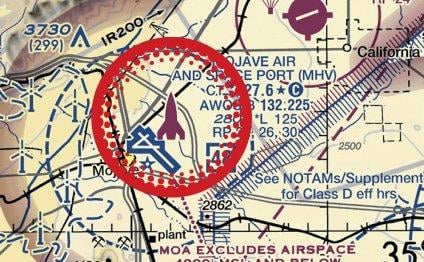
The FAA announced on May 5 that it is marking more space launch activity areas on the digital VFR raster charts it makes available to pilots. “Adding space launch activity areas to the navigation charts used by pilots who fly visually responds to the recent and expected continued growth of...
Subscription Required
This content requires a subscription to one of the Aviation Week Intelligence Network (AWIN) bundles.
Schedule a demo today to find out how you can access this content and similar content related to your area of the global aviation industry.
Already an AWIN subscriber? Login
Did you know? Aviation Week has won top honors multiple times in the Jesse H. Neal National Business Journalism Awards, the business-to-business media equivalent of the Pulitzer Prizes.
Related Content