Micro-UAV, Software Rival Satellite Image-Making
Credit: Aurora Flight Sciences
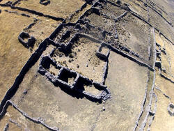
Small backpack-carried UAVs with still cameras can create large-area, three-dimensional digital maps with better resolution than satellite imagery, and in far less time than traditional techniques. That is the lesson of a just-completed series of tests at a 13,000-ft.-elevation archaeological site...
Subscription Required
This content requires a subscription to one of the Aviation Week Intelligence Network (AWIN) bundles.
Schedule a demo today to find out how you can access this content and similar content related to your area of the global aviation industry.
Already an AWIN subscriber? Login
Did you know? Aviation Week has won top honors multiple times in the Jesse H. Neal National Business Journalism Awards, the business-to-business media equivalent of the Pulitzer Prizes.
Related Content